Yanguas elevation
Yanguas (Castille and León, Provincia de Soria), Spain elevation is 989 meters and Yanguas elevation in feet is 3245 ft above sea level [src 1]. Yanguas is a seat of a third-order administrative division (feature code) with elevation that is 386 meters (1266 ft) bigger than average city elevation in Spain.
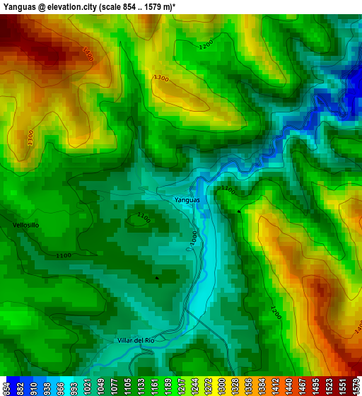
Below is the Elevation map of Yanguas, which displays elevation range with different colors. Scale of the first map is from 854 to 1579 m (2802 to 5180 ft) with average elevation of 1158.6 meters (=3801 ft) [note 1]
These maps also provides idea of topography and contour of this city, they are displayed at different zoom levels. More info about maps, scale and edge coordinates you can find below images.
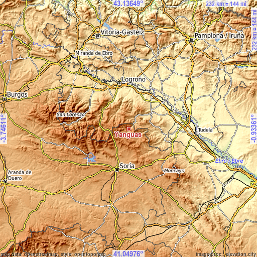
| \ | Map #1 | Topo.Map |
| Scale [m] | 854..1579 m | × |
| Scale [ft] | 2802..5180 ft | × |
| Average | 1158.6 m = 3801 ft | × |
| Width | 7.25 km = 4.5 mi | 232 km = 144.2 mi |
| Height | 7.25 km = 4.5 mi | 232 km = 144.2 mi |
| ↑Max Latitude | 42.134307° | 43.13649° |
| Latitude at center | 42.10171° | 42.10171° |
| ↓Min Latitude | 42.069096° | 41.04976° |
| ← Min Longitude | -2.383805° | -3.74611° |
| Longitude center | -2.33986° | -2.33986° |
| →Max Longitude | -2.295915° | -0.93361° |
Nearby cities:
Cities around Yanguas sort by population:
• San Pedro Manrique elevation 1081 m
12.1 km,  132°
132°
• Arnedillo 672 m
15 km,  34°
34°
• Villar del Río 1009 m
3 km,  197°
197°
• Enciso 800 m
7.9 km,  47°
47°
• Munilla 803 m
10.4 km,  20°
20°
• Oncala 1304 m
14.8 km,  171°
171°
• Ajamil 1046 m
14.2 km,  300°
300°
• Santa Cruz de Yanguas 1215 m
10 km,  244°
244°
• Rabanera 974 m
15.5 km,  308°
308°
• Vizmanos 1207 m
10.4 km,  213°
213°
• Hornillos de Cameros 1142 m
13.7 km,  331°
331°
• Zarzosa 975 m
9 km,  358°
358°
Multilingual:
 En español:
Yanguas elevación 989 m.
 En France:
Yanguas élévation 989 m.


Sources and notes:
- [note 1] Map square and city borders are not equal. Map elevation data is calculated only from area inside that square.
- [src 1] Elevation data from geonames database provided with same terms of usage.
- [src 2] The elevation map of Yanguas is generated using elevation data from NASA's 3 arcsec (90m) resolution SRTM data.
- [src 3] Base (background) map © OpenStreetMap contributors tiles are generated by Geofabrik and OpenTopoMap.
Copyright & License:
This Yanguas Elevation Map is licensed under CC BY-SA. You may reuse any part from this page, if you give a proper credit by linking to this URL:
 More info on terms of use page.