Zarzosa elevation
Zarzosa (La Rioja, Provincia de La Rioja), Spain elevation is 975 meters and Zarzosa elevation in feet is 3199 ft above sea level [src 1]. Zarzosa is a seat of a third-order administrative division (feature code) with elevation that is 372 meters (1220 ft) bigger than average city elevation in Spain.
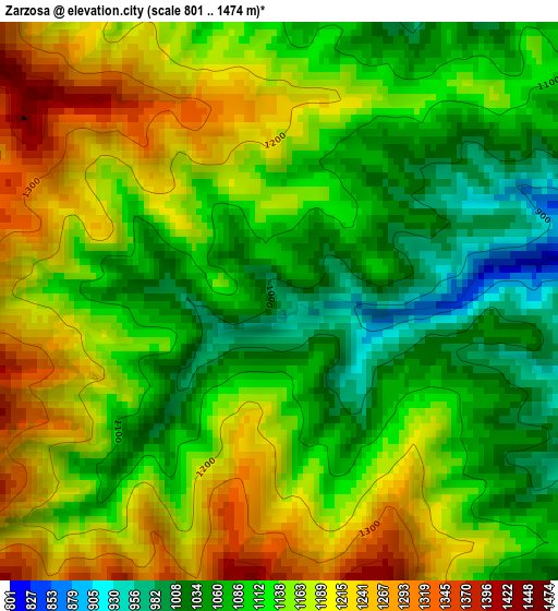
Below is the Elevation map of Zarzosa, which displays elevation range with different colors. Scale of the first map is from 801 to 1474 m (2628 to 4836 ft) with average elevation of 1136 meters (=3727 ft) [note 1]
These maps also provides idea of topography and contour of this city, they are displayed at different zoom levels. More info about maps, scale and edge coordinates you can find below images.
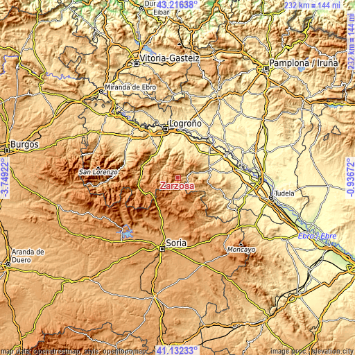
| \ | Map #1 | Topo.Map |
| Scale [m] | 801..1474 m | × |
| Scale [ft] | 2628..4836 ft | × |
| Average | 1136 m = 3727 ft | × |
| Width | 7.24 km = 4.5 mi | 231.7 km = 144 mi |
| Height | 7.24 km = 4.5 mi | 231.7 km = 144 mi |
| ↑Max Latitude | 42.215495° | 43.21638° |
| Latitude at center | 42.18294° | 42.18294° |
| ↓Min Latitude | 42.150368° | 41.13233° |
| ← Min Longitude | -2.386915° | -3.74922° |
| Longitude center | -2.34297° | -2.34297° |
| →Max Longitude | -2.299025° | -0.93672° |
Nearby cities:
Cities around Zarzosa sort by population:
• Arnedillo elevation 672 m
9.4 km,  69°
69°
• Villar del Río 1009 m
11.9 km,  183°
183°
• San Román de Cameros 850 m
12.1 km,  297°
297°
• Enciso 800 m
7.1 km,  121°
121°
• Yanguas 989 m
9 km, 178°
• Munilla 803 m
4 km,  80°
80°
• Ajamil 1046 m
12 km,  261°
261°
• Jalón de Cameros 885 m
12.7 km,  287°
287°
• Robres del Castillo 726 m
11.1 km,  21°
21°
• Rabanera 974 m
11.9 km,  273°
273°
• Terroba 788 m
11.8 km,  315°
315°
• Hornillos de Cameros 1142 m
7 km, 295°
Multilingual:
 En español:
Zarzosa elevación 975 m.
 En France:
Zarzosa élévation 975 m.


Sources and notes:
- [note 1] Map square and city borders are not equal. Map elevation data is calculated only from area inside that square.
- [src 1] Elevation data from geonames database provided with same terms of usage.
- [src 2] The elevation map of Zarzosa is generated using elevation data from NASA's 3 arcsec (90m) resolution SRTM data.
- [src 3] Base (background) map © OpenStreetMap contributors tiles are generated by Geofabrik and OpenTopoMap.
Copyright & License:
This Zarzosa Elevation Map is licensed under CC BY-SA. You may reuse any part from this page, if you give a proper credit by linking to this URL:
 More info on terms of use page.