Santibáñez del Val elevation
Santibáñez del Val (Castille and León, Provincia de Burgos), Spain elevation is 941 meters and Santibáñez del Val elevation in feet is 3087 ft above sea level [src 1]. Santibáñez del Val is a seat of a third-order administrative division (feature code) with elevation that is 338 meters (1109 ft) bigger than average city elevation in Spain.
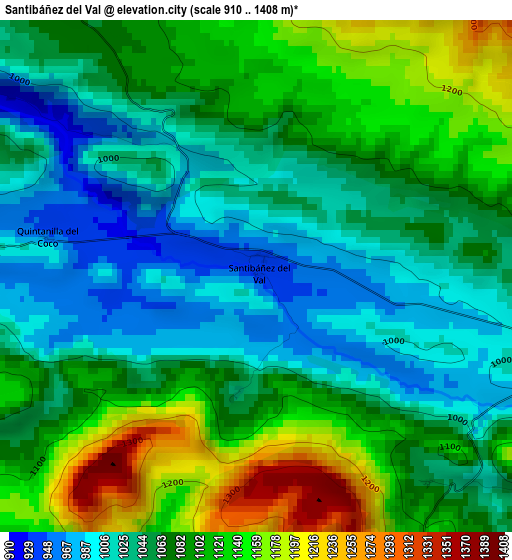
Below is the Elevation map of Santibáñez del Val, which displays elevation range with different colors. Scale of the first map is from 910 to 1408 m (2986 to 4619 ft) with average elevation of 1072.8 meters (=3520 ft) [note 1]
These maps also provides idea of topography and contour of this city, they are displayed at different zoom levels. More info about maps, scale and edge coordinates you can find below images.
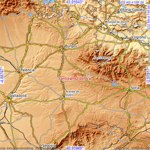
| \ | Map #1 | Topo.Map |
| Scale [m] | 910..1408 m | × |
| Scale [ft] | 2986..4619 ft | × |
| Average | 1072.8 m = 3520 ft | × |
| Width | 7.27 km = 4.5 mi | 232.5 km = 144.5 mi |
| Height | 7.27 km = 4.5 mi | 232.5 km = 144.5 mi |
| ↑Max Latitude | 42.006203° | 43.01043° |
| Latitude at center | 41.97354° | 41.97354° |
| ↓Min Latitude | 41.94086° | 40.91949° |
| ← Min Longitude | -3.525365° | -4.88767° |
| Longitude center | -3.48142° | -3.48142° |
| →Max Longitude | -3.437475° | -2.07517° |
Nearby cities:
Cities around Santibáñez del Val sort by population:
• Covarrubias elevation 892 m
10 km,  341°
341°
• Santo Domingo de Silos 1032 m
5.4 km,  101°
101°
• Ciruelos de Cervera 1021 m
8.6 km,  208°
208°
• Puentedura 865 m
11.2 km,  312°
312°
• Quintanilla del Coco 960 m
3.1 km,  290°
290°
• Contreras 1029 m
7.8 km,  48°
48°
• Espinosa de Cervera 1031 m
8.6 km,  172°
172°
• Cebrecos 953 m
9.6 km,  277°
277°
• Mamolar 1081 m
11.1 km,  117°
117°
• Retuerta 905 m
6.6 km, 341°
• Carazo 1129 m
10.6 km,  93°
93°
• Tejada 1086 m
5 km,  242°
242°
Multilingual:
 En español:
Santibáñez del Val elevación 941 m.
 En France:
Santibáñez del Val élévation 941 m.
 Auf Deutsch:
Santibáñez del Val höhe über dem Meeresspiegel ist 941 m.
 На русском:
Santibáñez del Val высота над уровнем моря 941 м
Sources and notes:
- [note 1] Map square and city borders are not equal. Map elevation data is calculated only from area inside that square.
- [src 1] Elevation data from geonames database provided with same terms of usage.
- [src 2] The elevation map of Santibáñez del Val is generated using elevation data from NASA's 3 arcsec (90m) resolution SRTM data.
- [src 3] Base (background) map © OpenStreetMap contributors tiles are generated by Geofabrik and OpenTopoMap.
Copyright & License:
This Santibáñez del Val Elevation Map is licensed under CC BY-SA. You may reuse any part from this page, if you give a proper credit by linking to this URL:
 More info on terms of use page.