Contreras elevation
Contreras (Castille and León, Provincia de Burgos), Spain elevation is 1029 meters and Contreras elevation in feet is 3376 ft above sea level [src 1]. Contreras is a seat of a third-order administrative division (feature code) with elevation that is 426 meters (1398 ft) bigger than average city elevation in Spain.
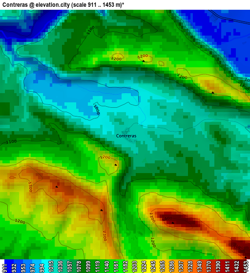
Below is the Elevation map of Contreras, which displays elevation range with different colors. Scale of the first map is from 911 to 1453 m (2989 to 4767 ft) with average elevation of 1114.3 meters (=3656 ft) [note 1]
These maps also provides idea of topography and contour of this city, they are displayed at different zoom levels. More info about maps, scale and edge coordinates you can find below images.
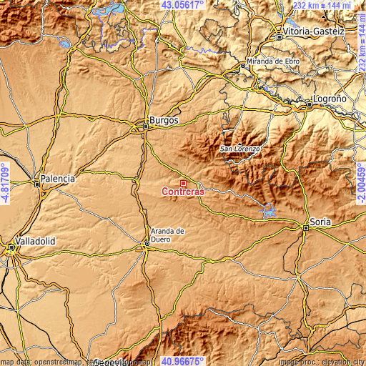
| \ | Map #1 | Topo.Map |
| Scale [m] | 911..1453 m | × |
| Scale [ft] | 2989..4767 ft | × |
| Average | 1114.3 m = 3656 ft | × |
| Width | 7.26 km = 4.5 mi | 232.3 km = 144.3 mi |
| Height | 7.26 km = 4.5 mi | 232.3 km = 144.3 mi |
| ↑Max Latitude | 42.052679° | 43.05617° |
| Latitude at center | 42.02004° | 42.02004° |
| ↓Min Latitude | 41.987384° | 40.96675° |
| ← Min Longitude | -3.454785° | -4.81709° |
| Longitude center | -3.41084° | -3.41084° |
| →Max Longitude | -3.366895° | -2.00459° |
Nearby cities:
Cities around Contreras sort by population:
• Santo Domingo de Silos elevation 1032 m
6.3 km,  184°
184°
• Barbadillo del Mercado 953 m
4.9 km,  65°
65°
• Hortigüela 940 m
5.5 km,  347°
347°
• Santibáñez del Val 941 m
7.8 km,  228°
228°
• Mambrillas de Lara 992 m
9.3 km,  332°
332°
• Retuerta 905 m
8 km,  277°
277°
• Carazo 1129 m
7.5 km,  140°
140°
• Pinilla de los Moros 971 m
8.7 km,  52°
52°
• Cascajares de la Sierra 928 m
4.7 km,  11°
11°
• Villanueva de Carazo 1059 m
8.3 km,  120°
120°
• Villaespasa 962 m
8.9 km,  3°
3°
• Jaramillo Quemado 988 m
8.5 km,  30°
30°
Multilingual:
 En español:
Contreras elevación 1029 m.
 En France:
Contreras élévation 1029 m.
 Auf Deutsch:
Contreras höhe über dem Meeresspiegel ist 1029 m.

Sources and notes:
- [note 1] Map square and city borders are not equal. Map elevation data is calculated only from area inside that square.
- [src 1] Elevation data from geonames database provided with same terms of usage.
- [src 2] The elevation map of Contreras is generated using elevation data from NASA's 3 arcsec (90m) resolution SRTM data.
- [src 3] Base (background) map © OpenStreetMap contributors tiles are generated by Geofabrik and OpenTopoMap.
Copyright & License:
This Contreras Elevation Map is licensed under CC BY-SA. You may reuse any part from this page, if you give a proper credit by linking to this URL:
 More info on terms of use page.