Tejada elevation
Tejada (Castille and León, Provincia de Burgos), Spain elevation is 1086 meters and Tejada elevation in feet is 3563 ft above sea level [src 1]. Tejada is a seat of a third-order administrative division (feature code) with elevation that is 483 meters (1585 ft) bigger than average city elevation in Spain.
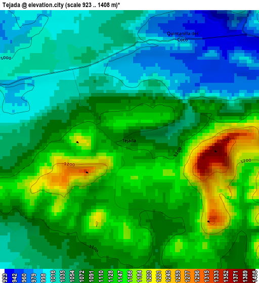
Below is the Elevation map of Tejada, which displays elevation range with different colors. Scale of the first map is from 923 to 1408 m (3028 to 4619 ft) with average elevation of 1083.1 meters (=3553 ft) [note 1]
These maps also provides idea of topography and contour of this city, they are displayed at different zoom levels. More info about maps, scale and edge coordinates you can find below images.
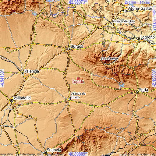
| \ | Map #1 | Topo.Map |
| Scale [m] | 923..1408 m | × |
| Scale [ft] | 3028..4619 ft | × |
| Average | 1083.1 m = 3553 ft | × |
| Width | 7.27 km = 4.5 mi | 232.6 km = 144.5 mi |
| Height | 7.27 km = 4.5 mi | 232.6 km = 144.5 mi |
| ↑Max Latitude | 41.985164° | 42.98973° |
| Latitude at center | 41.95249° | 41.95249° |
| ↓Min Latitude | 41.9198° | 40.89809° |
| ← Min Longitude | -3.579085° | -4.94139° |
| Longitude center | -3.53514° | -3.53514° |
| →Max Longitude | -3.491195° | -2.12889° |
Nearby cities:
Cities around Tejada sort by population:
• Covarrubias elevation 892 m
11.9 km,  6°
6°
• Santo Domingo de Silos 1032 m
9.8 km,  82°
82°
• Ciruelos de Cervera 1021 m
5.2 km,  175°
175°
• Puentedura 865 m
10.6 km,  338°
338°
• Quintanilla del Coco 960 m
3.8 km,  24°
24°
• Solarana 903 m
10.4 km,  281°
281°
• Espinosa de Cervera 1031 m
8.3 km,  138°
138°
• Nebreda 917 m
8.4 km, 282°
• Santibáñez del Val 941 m
5 km,  62°
62°
• Cilleruelo de Arriba 966 m
11.7 km,  243°
243°
• Cebrecos 953 m
6.2 km,  304°
304°
• Retuerta 905 m
8.9 km, 15°
Multilingual:
 En español:
Tejada elevación 1086 m.
 En France:
Tejada élévation 1086 m.


Sources and notes:
- [note 1] Map square and city borders are not equal. Map elevation data is calculated only from area inside that square.
- [src 1] Elevation data from geonames database provided with same terms of usage.
- [src 2] The elevation map of Tejada is generated using elevation data from NASA's 3 arcsec (90m) resolution SRTM data.
- [src 3] Base (background) map © OpenStreetMap contributors tiles are generated by Geofabrik and OpenTopoMap.
Copyright & License:
This Tejada Elevation Map is licensed under CC BY-SA. You may reuse any part from this page, if you give a proper credit by linking to this URL:
 More info on terms of use page.