Santiuste elevation
Santiuste (Castille-La Mancha, Provincia de Guadalajara), Spain elevation is 919 meters and Santiuste elevation in feet is 3015 ft above sea level [src 1]. Santiuste is a seat of a third-order administrative division (feature code) with elevation that is 316 meters (1037 ft) bigger than average city elevation in Spain.
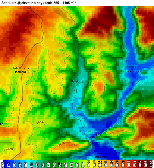
Below is the Elevation map of Santiuste, which displays elevation range with different colors. Scale of the first map is from 865 to 1105 m (2838 to 3625 ft) with average elevation of 985.3 meters (=3233 ft) [note 1]
These maps also provides idea of topography and contour of this city, they are displayed at different zoom levels. More info about maps, scale and edge coordinates you can find below images.
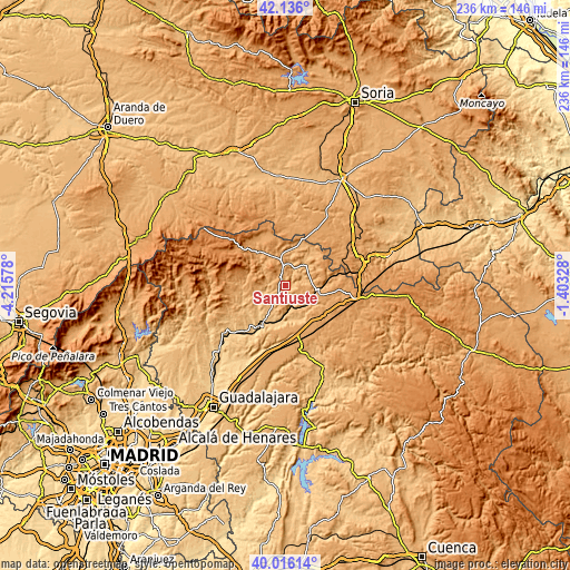
| \ | Map #1 | Topo.Map |
| Scale [m] | 865..1105 m | × |
| Scale [ft] | 2838..3625 ft | × |
| Average | 985.3 m = 3233 ft | × |
| Width | 7.37 km = 4.6 mi | 235.7 km = 146.5 mi |
| Height | 7.37 km = 4.6 mi | 235.7 km = 146.5 mi |
| ↑Max Latitude | 41.117735° | 42.136° |
| Latitude at center | 41.08462° | 41.08462° |
| ↓Min Latitude | 41.051488° | 40.01614° |
| ← Min Longitude | -2.853475° | -4.21578° |
| Longitude center | -2.80953° | -2.80953° |
| →Max Longitude | -2.765585° | -1.40328° |
Nearby cities:
Cities around Santiuste sort by population:
• Atienza elevation 1163 m
13.5 km,  337°
337°
• Robledo de Corpes 1148 m
12.4 km,  287°
287°
• Pinilla de Jadraque 838 m
13.3 km,  237°
237°
• Pálmaces de Jadraque 918 m
9 km,  249°
249°
• Cendejas de la Torre 965 m
12.2 km,  196°
196°
• Baides 849 m
9.1 km,  162°
162°
• Huérmeces del Cerro 877 m
3.6 km, 163°
• Viana de Jadraque 876 m
7.3 km,  152°
152°
• Cincovillas 1020 m
13.4 km,  356°
356°
• Rebollosa de Jadraque 1031 m
2.8 km,  283°
283°
• Torremocha de Jadraque 933 m
10.5 km,  225°
225°
• Negredo 988 m
7.6 km,  212°
212°
Multilingual:
 En español:
Santiuste elevación 919 m.
 En France:
Santiuste élévation 919 m.
 Auf Deutsch:
Santiuste höhe über dem Meeresspiegel ist 919 m.

Sources and notes:
- [note 1] Map square and city borders are not equal. Map elevation data is calculated only from area inside that square.
- [src 1] Elevation data from geonames database provided with same terms of usage.
- [src 2] The elevation map of Santiuste is generated using elevation data from NASA's 3 arcsec (90m) resolution SRTM data.
- [src 3] Base (background) map © OpenStreetMap contributors tiles are generated by Geofabrik and OpenTopoMap.
Copyright & License:
This Santiuste Elevation Map is licensed under CC BY-SA. You may reuse any part from this page, if you give a proper credit by linking to this URL:
 More info on terms of use page.