Atienza elevation
Atienza (Castille-La Mancha, Provincia de Guadalajara), Spain elevation is 1163 meters and Atienza elevation in feet is 3816 ft above sea level [src 1]. Atienza is a seat of a third-order administrative division (feature code) with elevation that is 560 meters (1837 ft) bigger than average city elevation in Spain.
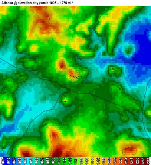
Below is the Elevation map of Atienza, which displays elevation range with different colors. Scale of the first map is from 1005 to 1276 m (3297 to 4186 ft) with average elevation of 1107 meters (=3632 ft) [note 1]
These maps also provides idea of topography and contour of this city, they are displayed at different zoom levels. More info about maps, scale and edge coordinates you can find below images.
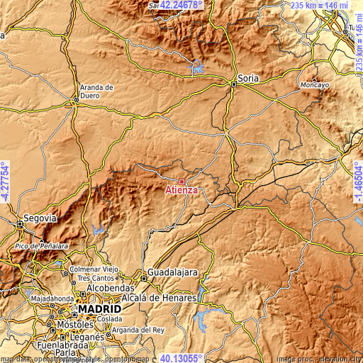
| \ | Map #1 | Topo.Map |
| Scale [m] | 1005..1276 m | × |
| Scale [ft] | 3297..4186 ft | × |
| Average | 1107 m = 3632 ft | × |
| Width | 7.35 km = 4.6 mi | 235.3 km = 146.2 mi |
| Height | 7.35 km = 4.6 mi | 235.3 km = 146.2 mi |
| ↑Max Latitude | 41.230278° | 42.24678° |
| Latitude at center | 41.19722° | 41.19722° |
| ↓Min Latitude | 41.164145° | 40.13055° |
| ← Min Longitude | -2.915235° | -4.27754° |
| Longitude center | -2.87129° | -2.87129° |
| →Max Longitude | -2.827345° | -1.46504° |
Nearby cities:
Cities around Atienza sort by population:
• Robledo de Corpes elevation 1148 m
11 km,  216°
216°
• Miedes de Atienza 1150 m
10.9 km,  314°
314°
• Romanillos de Atienza 1117 m
8.1 km,  342°
342°
• Prádena de Atienza 1167 m
11.7 km,  256°
256°
• Barcones 1099 m
11.4 km,  23°
23°
• Cincovillas 1020 m
4.5 km,  78°
78°
• Rebollosa de Jadraque 1031 m
12.1 km,  168°
168°
• Ujados 1144 m
11.9 km,  290°
290°
• Alcolea de las Peñas 1012 m
7.4 km, 79°
• Hijes 1166 m
12.3 km,  299°
299°
• Bañuelos 1148 m
10.5 km, 339°
• Tordelrábano 1020 m
9.8 km, 76°
Multilingual:
 En español:
Atienza elevación 1163 m.
 En France:
Atienza élévation 1163 m.
 Auf Deutsch:
Atienza höhe über dem Meeresspiegel ist 1163 m.

Sources and notes:
- [note 1] Map square and city borders are not equal. Map elevation data is calculated only from area inside that square.
- [src 1] Elevation data from geonames database provided with same terms of usage.
- [src 2] The elevation map of Atienza is generated using elevation data from NASA's 3 arcsec (90m) resolution SRTM data.
- [src 3] Base (background) map © OpenStreetMap contributors tiles are generated by Geofabrik and OpenTopoMap.
Copyright & License:
This Atienza Elevation Map is licensed under CC BY-SA. You may reuse any part from this page, if you give a proper credit by linking to this URL:
 More info on terms of use page.