Hijes elevation
Hijes (Castille-La Mancha, Provincia de Guadalajara), Spain elevation is 1166 meters and Hijes elevation in feet is 3825 ft above sea level [src 1]. Hijes is a seat of a third-order administrative division (feature code) with elevation that is 563 meters (1847 ft) bigger than average city elevation in Spain.
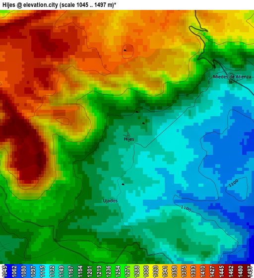
Below is the Elevation map of Hijes, which displays elevation range with different colors. Scale of the first map is from 1045 to 1497 m (3428 to 4911 ft) with average elevation of 1246.4 meters (=4089 ft) [note 1]
These maps also provides idea of topography and contour of this city, they are displayed at different zoom levels. More info about maps, scale and edge coordinates you can find below images.
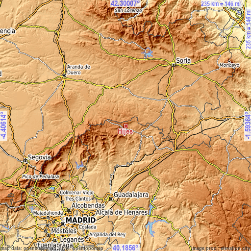
| \ | Map #1 | Topo.Map |
| Scale [m] | 1045..1497 m | × |
| Scale [ft] | 3428..4911 ft | × |
| Average | 1246.4 m = 4089 ft | × |
| Width | 7.35 km = 4.6 mi | 235.1 km = 146.1 mi |
| Height | 7.35 km = 4.6 mi | 235.1 km = 146.1 mi |
| ↑Max Latitude | 41.284421° | 42.30007° |
| Latitude at center | 41.25139° | 41.25139° |
| ↓Min Latitude | 41.218343° | 40.1856° |
| ← Min Longitude | -3.043835° | -4.40614° |
| Longitude center | -2.99989° | -2.99989° |
| →Max Longitude | -2.955945° | -1.59364° |
Nearby cities:
Cities around Hijes sort by population:
• Retortillo de Soria elevation 1234 m
6.8 km,  12°
12°
• Condemios de Arriba 1305 m
11.2 km,  249°
249°
• Miedes de Atienza 1150 m
3.5 km,  60°
60°
• Campisábalos 1359 m
11.3 km,  278°
278°
• Romanillos de Atienza 1117 m
8.5 km,  78°
78°
• Gascueña de Bornova 1205 m
12.2 km,  187°
187°
• Prádena de Atienza 1167 m
8.8 km,  184°
184°
• Albendiego 1188 m
5.1 km,  238°
238°
• Somolinos 1245 m
5.1 km,  263°
263°
• Ujados 1144 m
1.8 km, 192°
• Condemios de Abajo 1290 m
9.2 km, 245°
• Bañuelos 1148 m
8.1 km, 61°
Multilingual:
 En español:
Hijes elevación 1166 m.
 En France:
Hijes élévation 1166 m.


Sources and notes:
- [note 1] Map square and city borders are not equal. Map elevation data is calculated only from area inside that square.
- [src 1] Elevation data from geonames database provided with same terms of usage.
- [src 2] The elevation map of Hijes is generated using elevation data from NASA's 3 arcsec (90m) resolution SRTM data.
- [src 3] Base (background) map © OpenStreetMap contributors tiles are generated by Geofabrik and OpenTopoMap.
Copyright & License:
This Hijes Elevation Map is licensed under CC BY-SA. You may reuse any part from this page, if you give a proper credit by linking to this URL:
 More info on terms of use page.