Baides elevation
Baides (Castille-La Mancha, Provincia de Guadalajara), Spain elevation is 849 meters and Baides elevation in feet is 2785 ft above sea level [src 1]. Baides is a seat of a third-order administrative division (feature code) with elevation that is 246 meters (807 ft) bigger than average city elevation in Spain.
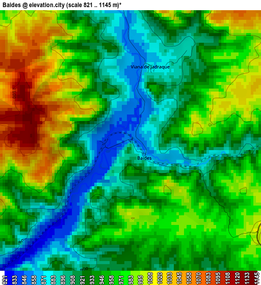
Below is the Elevation map of Baides, which displays elevation range with different colors. Scale of the first map is from 821 to 1145 m (2694 to 3757 ft) with average elevation of 950.5 meters (=3118 ft) [note 1]
These maps also provides idea of topography and contour of this city, they are displayed at different zoom levels. More info about maps, scale and edge coordinates you can find below images.
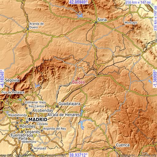
| \ | Map #1 | Topo.Map |
| Scale [m] | 821..1145 m | × |
| Scale [ft] | 2694..3757 ft | × |
| Average | 950.5 m = 3118 ft | × |
| Width | 7.37 km = 4.6 mi | 236 km = 146.6 mi |
| Height | 7.37 km = 4.6 mi | 236 km = 146.6 mi |
| ↑Max Latitude | 41.040004° | 42.05949° |
| Latitude at center | 41.00685° | 41.00685° |
| ↓Min Latitude | 40.973679° | 39.93712° |
| ← Min Longitude | -2.820145° | -4.18245° |
| Longitude center | -2.7762° | -2.7762° |
| →Max Longitude | -2.732255° | -1.36995° |
Nearby cities:
Cities around Baides sort by population:
• Mandayona elevation 877 m
6 km,  158°
158°
• Matillas 882 m
8.6 km,  215°
215°
• Algora 1112 m
10.4 km,  117°
117°
• Castejón de Henares 949 m
7.7 km,  186°
186°
• Mirabueno 1068 m
8.2 km,  147°
147°
• Cendejas de la Torre 965 m
7 km,  243°
243°
• Villaseca de Henares 861 m
5.5 km,  199°
199°
• Huérmeces del Cerro 877 m
5.5 km,  341°
341°
• Viana de Jadraque 876 m
2.2 km,  14°
14°
• Santiuste 919 m
9.1 km, 342°
• Torremocha de Jadraque 933 m
10.4 km,  277°
277°
• Negredo 988 m
7.3 km,  288°
288°
Multilingual:
 En español:
Baides elevación 849 m.
 En France:
Baides élévation 849 m.


Sources and notes:
- [note 1] Map square and city borders are not equal. Map elevation data is calculated only from area inside that square.
- [src 1] Elevation data from geonames database provided with same terms of usage.
- [src 2] The elevation map of Baides is generated using elevation data from NASA's 3 arcsec (90m) resolution SRTM data.
- [src 3] Base (background) map © OpenStreetMap contributors tiles are generated by Geofabrik and OpenTopoMap.
Copyright & License:
This Baides Elevation Map is licensed under CC BY-SA. You may reuse any part from this page, if you give a proper credit by linking to this URL:
 More info on terms of use page.