Sigüenza elevation
Sigüenza (Castille-La Mancha, Provincia de Guadalajara), Spain elevation is 992 meters and Sigüenza elevation in feet is 3255 ft above sea level [src 1]. Sigüenza is a seat of a third-order administrative division (feature code) with elevation that is 389 meters (1276 ft) bigger than average city elevation in Spain.
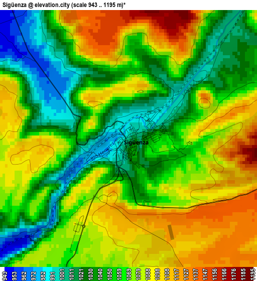
Below is the Elevation map of Sigüenza, which displays elevation range with different colors. Scale of the first map is from 943 to 1195 m (3094 to 3921 ft) with average elevation of 1064.3 meters (=3492 ft) [note 1]
These maps also provides idea of topography and contour of this city, they are displayed at different zoom levels. More info about maps, scale and edge coordinates you can find below images.
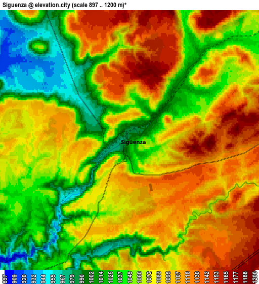
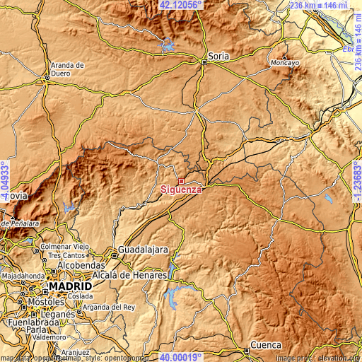
| \ | Map #1 | Map #2 | Topo.Map |
| Scale [m] | 943..1195 m | 897..1200 m | × |
| Scale [ft] | 3094..3921 ft | 2943..3937 ft | × |
| Average | 1064.3 m = 3492 ft | 1071 m = 3514 ft | × |
| Width | 7.37 km = 4.6 mi | 14.74 km = 9.2 mi | 235.8 km = 146.5 mi |
| Height | 7.37 km = 4.6 mi | 14.74 km = 9.2 mi | 235.8 km = 146.5 mi |
| ↑Max Latitude | 41.102043° | 41.135149° | 42.12056° |
| Latitude at center | 41.06892° | 41.06892° | 41.06892° |
| ↓Min Latitude | 41.03578° | 41.002624° | 40.00019° |
| ← Min Longitude | -2.687025° | -2.730971° | -4.04933° |
| Longitude center | -2.64308° | -2.64308° | -2.64308° |
| →Max Longitude | -2.599135° | -2.555189° | -1.23683° |
Nearby cities:
Cities around Sigüenza sort by population:
• Alcolea del Pinar elevation 1202 m
15.3 km,  104°
104°
• Mandayona 877 m
15.4 km,  215°
215°
• Torremocha del Campo 1088 m
10.3 km,  168°
168°
• Algora 1112 m
11.9 km,  189°
189°
• Mirabueno 1068 m
15.4 km,  206°
206°
• Sienes 1039 m
14.7 km,  356°
356°
• Saúca 1103 m
10.5 km,  113°
113°
• Baides 849 m
13.1 km,  238°
238°
• Huérmeces del Cerro 877 m
13 km,  262°
262°
• Viana de Jadraque 876 m
11.6 km,  245°
245°
• Estriégana 1107 m
10.1 km, 96°
• Santiuste 919 m
14.1 km,  277°
277°
Multilingual:
 En español:
Sigüenza elevación 992 m.
 En France:
Sigüenza élévation 992 m.
 Auf Deutsch:
Sigüenza höhe über dem Meeresspiegel ist 992 m.

Sources and notes:
- [note 1] Map square and city borders are not equal. Map elevation data is calculated only from area inside that square.
- [src 1] Elevation data from geonames database provided with same terms of usage.
- [src 2] The elevation map of Sigüenza is generated using elevation data from NASA's 3 arcsec (90m) resolution SRTM data.
- [src 3] Base (background) map © OpenStreetMap contributors tiles are generated by Geofabrik and OpenTopoMap.
Copyright & License:
This Sigüenza Elevation Map is licensed under CC BY-SA. You may reuse any part from this page, if you give a proper credit by linking to this URL:
 More info on terms of use page.