Sorlada elevation
Sorlada (Navarre, Provincia de Navarra), Spain elevation is 572 meters and Sorlada elevation in feet is 1877 ft above sea level [src 1]. Sorlada is a seat of a third-order administrative division (feature code) with elevation that is 31 meters (102 ft) smaller than average city elevation in Spain.
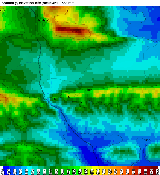
Below is the Elevation map of Sorlada, which displays elevation range with different colors. Scale of the first map is from 461 to 839 m (1512 to 2753 ft) with average elevation of 570.2 meters (=1871 ft) [note 1]
These maps also provides idea of topography and contour of this city, they are displayed at different zoom levels. More info about maps, scale and edge coordinates you can find below images.
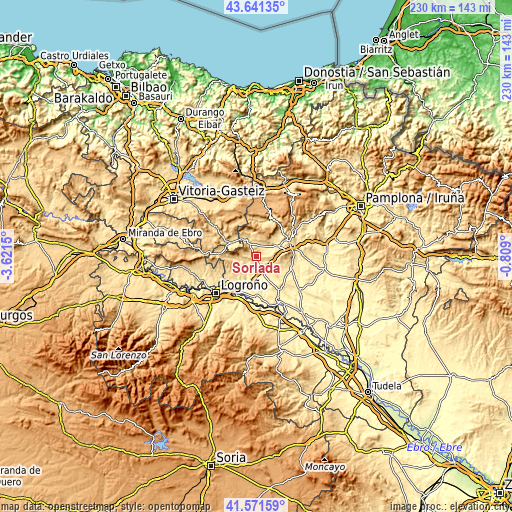
| \ | Map #1 | Topo.Map |
| Scale [m] | 461..839 m | × |
| Scale [ft] | 1512..2753 ft | × |
| Average | 570.2 m = 1871 ft | × |
| Width | 7.19 km = 4.5 mi | 230.1 km = 143 mi |
| Height | 7.19 km = 4.5 mi | 230.1 km = 143 mi |
| ↑Max Latitude | 42.647402° | 43.64135° |
| Latitude at center | 42.61507° | 42.61507° |
| ↓Min Latitude | 42.582721° | 41.57159° |
| ← Min Longitude | -2.259195° | -3.6215° |
| Longitude center | -2.21525° | -2.21525° |
| →Max Longitude | -2.171305° | -0.809° |
Nearby cities:
Cities around Sorlada sort by population:
• Los Arcos elevation 456 m
5.3 km,  159°
159°
• Ancín 486 m
5.5 km,  23°
23°
• Murieta 465 m
6.8 km,  47°
47°
• Desojo 523 m
5.7 km,  238°
238°
• Legaria 480 m
5.1 km,  41°
41°
• Abáigar 493 m
7 km,  58°
58°
• Etayo 595 m
5 km,  87°
87°
• Oco 495 m
4.9 km, 58°
• Piedramillera 613 m
2.1 km,  25°
25°
• Mirafuentes 641 m
5.3 km,  279°
279°
• Nazar 744 m
5.8 km,  294°
294°
• Olejua 574 m
6.1 km,  81°
81°
Multilingual:
 En español:
Sorlada elevación 572 m.
 En France:
Sorlada élévation 572 m.


Sources and notes:
- [note 1] Map square and city borders are not equal. Map elevation data is calculated only from area inside that square.
- [src 1] Elevation data from geonames database provided with same terms of usage.
- [src 2] The elevation map of Sorlada is generated using elevation data from NASA's 3 arcsec (90m) resolution SRTM data.
- [src 3] Base (background) map © OpenStreetMap contributors tiles are generated by Geofabrik and OpenTopoMap.
Copyright & License:
This Sorlada Elevation Map is licensed under CC BY-SA. You may reuse any part from this page, if you give a proper credit by linking to this URL:
 More info on terms of use page.