Abáigar elevation
Abáigar (Navarre, Provincia de Navarra), Spain elevation is 493 meters and Abáigar elevation in feet is 1617 ft above sea level [src 1]. Abáigar is a seat of a third-order administrative division (feature code) with elevation that is 110 meters (361 ft) smaller than average city elevation in Spain.
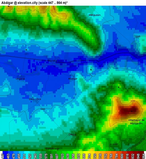
Below is the Elevation map of Abáigar, which displays elevation range with different colors. Scale of the first map is from 447 to 864 m (1467 to 2835 ft) with average elevation of 544.5 meters (=1786 ft) [note 1]
These maps also provides idea of topography and contour of this city, they are displayed at different zoom levels. More info about maps, scale and edge coordinates you can find below images.
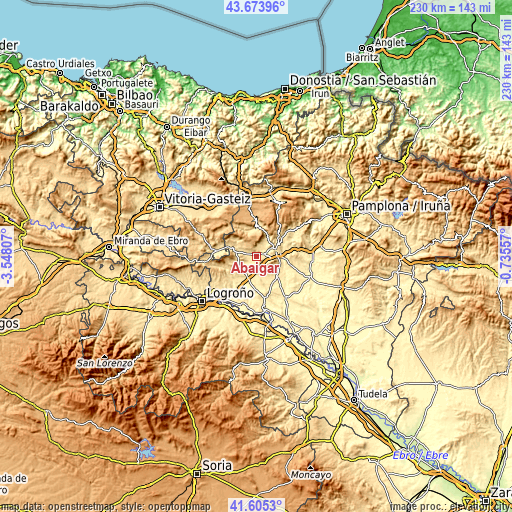
| \ | Map #1 | Topo.Map |
| Scale [m] | 447..864 m | × |
| Scale [ft] | 1467..2835 ft | × |
| Average | 544.5 m = 1786 ft | × |
| Width | 7.19 km = 4.5 mi | 230 km = 142.9 mi |
| Height | 7.19 km = 4.5 mi | 230 km = 142.9 mi |
| ↑Max Latitude | 42.680545° | 43.67396° |
| Latitude at center | 42.64823° | 42.64823° |
| ↓Min Latitude | 42.615899° | 41.6053° |
| ← Min Longitude | -2.185765° | -3.54807° |
| Longitude center | -2.14182° | -2.14182° |
| →Max Longitude | -2.097875° | -0.73557° |
Nearby cities:
Cities around Abáigar sort by population:
• Arróniz elevation 546 m
7.8 km,  148°
148°
• Ancín 486 m
4.1 km,  289°
289°
• Igúzquiza 515 m
4.6 km,  93°
93°
• Metauten 527 m
3.4 km,  16°
16°
• Murieta 465 m
1.4 km,  310°
310°
• Villamayor de Monjardín 680 m
3.7 km,  124°
124°
• Legaria 480 m
2.6 km,  272°
272°
• Etayo 595 m
3.6 km,  196°
196°
• Oco 495 m
2.2 km,  239°
239°
• Piedramillera 613 m
5.4 km,  250°
250°
• Olejua 574 m
2.8 km,  180°
180°
• Sorlada 572 m
7 km, 238°
Multilingual:
 En español:
Abáigar elevación 493 m.
 En France:
Abáigar élévation 493 m.


Sources and notes:
- [note 1] Map square and city borders are not equal. Map elevation data is calculated only from area inside that square.
- [src 1] Elevation data from geonames database provided with same terms of usage.
- [src 2] The elevation map of Abáigar is generated using elevation data from NASA's 3 arcsec (90m) resolution SRTM data.
- [src 3] Base (background) map © OpenStreetMap contributors tiles are generated by Geofabrik and OpenTopoMap.
Copyright & License:
This Abáigar Elevation Map is licensed under CC BY-SA. You may reuse any part from this page, if you give a proper credit by linking to this URL:
 More info on terms of use page.