Los Arcos elevation
Los Arcos (Navarre, Provincia de Navarra), Spain elevation is 456 meters and Los Arcos elevation in feet is 1496 ft above sea level [src 1]. Los Arcos is a populated place (feature code) with elevation that is 147 meters (482 ft) smaller than average city elevation in Spain.
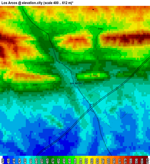
Below is the Elevation map of Los Arcos, which displays elevation range with different colors. Scale of the first map is from 400 to 612 m (1312 to 2008 ft) with average elevation of 473.6 meters (=1554 ft) [note 1]
These maps also provides idea of topography and contour of this city, they are displayed at different zoom levels. More info about maps, scale and edge coordinates you can find below images.
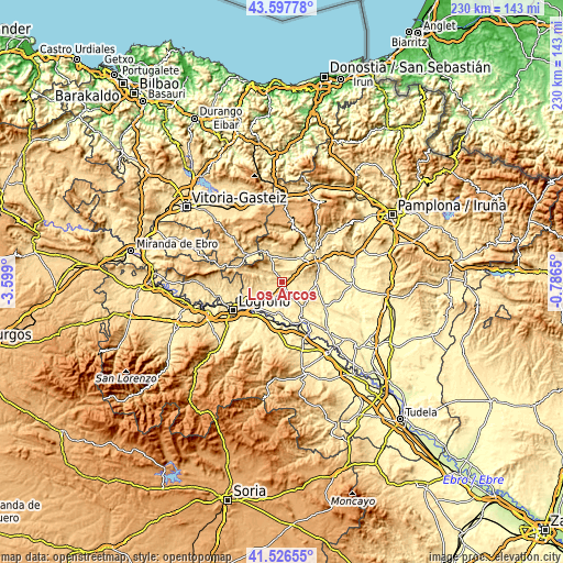
| \ | Map #1 | Topo.Map |
| Scale [m] | 400..612 m | × |
| Scale [ft] | 1312..2008 ft | × |
| Average | 473.6 m = 1554 ft | × |
| Width | 7.2 km = 4.5 mi | 230.3 km = 143.1 mi |
| Height | 7.2 km = 4.5 mi | 230.3 km = 143.1 mi |
| ↑Max Latitude | 42.603115° | 43.59778° |
| Latitude at center | 42.57076° | 42.57076° |
| ↓Min Latitude | 42.538388° | 41.52655° |
| ← Min Longitude | -2.236695° | -3.599° |
| Longitude center | -2.19275° | -2.19275° |
| →Max Longitude | -2.148805° | -0.7865° |
Nearby cities:
Cities around Los Arcos sort by population:
• Arróniz elevation 546 m
8.4 km,  76°
76°
• Torres del Río 477 m
6.9 km,  252°
252°
• Legaria 480 m
8.9 km,  10°
10°
• Desojo 523 m
6.9 km,  285°
285°
• Etayo 595 m
6 km,  31°
31°
• Armañanzas 494 m
7.6 km,  260°
260°
• Oco 495 m
7.8 km,  16°
16°
• Piedramillera 613 m
6.9 km,  352°
352°
• Mirafuentes 641 m
9.2 km,  309°
309°
• Olejua 574 m
7.2 km,  35°
35°
• Sorlada 572 m
5.3 km,  339°
339°
• Sansol 495 m
6.4 km, 252°
Multilingual:
 En español:
Los Arcos elevación 456 m.
 En France:
Los Arcos élévation 456 m.
 Auf Deutsch:
Los Arcos höhe über dem Meeresspiegel ist 456 m.

Sources and notes:
- [note 1] Map square and city borders are not equal. Map elevation data is calculated only from area inside that square.
- [src 1] Elevation data from geonames database provided with same terms of usage.
- [src 2] The elevation map of Los Arcos is generated using elevation data from NASA's 3 arcsec (90m) resolution SRTM data.
- [src 3] Base (background) map © OpenStreetMap contributors tiles are generated by Geofabrik and OpenTopoMap.
Copyright & License:
This Los Arcos Elevation Map is licensed under CC BY-SA. You may reuse any part from this page, if you give a proper credit by linking to this URL:
 More info on terms of use page.