Tolbaños elevation
Tolbaños (Castille and León, Provincia de Ávila), Spain elevation is 1115 meters and Tolbaños elevation in feet is 3658 ft above sea level [src 1]. Tolbaños is a seat of a third-order administrative division (feature code) with elevation that is 512 meters (1680 ft) bigger than average city elevation in Spain.
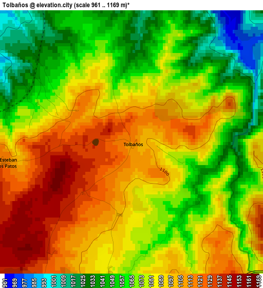
Below is the Elevation map of Tolbaños, which displays elevation range with different colors. Scale of the first map is from 961 to 1169 m (3153 to 3835 ft) with average elevation of 1080.3 meters (=3544 ft) [note 1]
These maps also provides idea of topography and contour of this city, they are displayed at different zoom levels. More info about maps, scale and edge coordinates you can find below images.
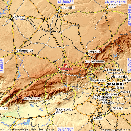
| \ | Map #1 | Topo.Map |
| Scale [m] | 961..1169 m | × |
| Scale [ft] | 3153..3835 ft | × |
| Average | 1080.3 m = 3544 ft | × |
| Width | 7.4 km = 4.6 mi | 236.9 km = 147.2 mi |
| Height | 7.4 km = 4.6 mi | 236.9 km = 147.2 mi |
| ↑Max Latitude | 40.784962° | 41.80843° |
| Latitude at center | 40.75168° | 40.75168° |
| ↓Min Latitude | 40.718381° | 39.67786° |
| ← Min Longitude | -4.625855° | -5.98816° |
| Longitude center | -4.58191° | -4.58191° |
| →Max Longitude | -4.537965° | -3.17566° |
Nearby cities:
Cities around Tolbaños sort by population:
• Maello elevation 1032 m
8.7 km,  42°
42°
• Cardeñosa 1108 m
13.8 km,  265°
265°
• Mingorría 1037 m
7.1 km, 270°
• Velayos 936 m
10.6 km,  340°
340°
• Labajos 1067 m
11.4 km,  27°
27°
• Vega de Santa María 946 m
10.7 km,  331°
331°
• Mediana de Voltoya 1111 m
5.8 km,  164°
164°
• Santo Domingo de las Posadas 926 m
8 km, 326°
• Ojos-Albos 1232 m
7.5 km,  132°
132°
• Pozanco 911 m
9.1 km,  307°
307°
• Berrocalejo de Aragona 1089 m
6.5 km,  189°
189°
• San Esteban de los Patos 1114 m
3.6 km,  261°
261°
Multilingual:
 En español:
Tolbaños elevación 1115 m.
 En France:
Tolbaños élévation 1115 m.
 Auf Deutsch:
Tolbaños höhe über dem Meeresspiegel ist 1115 m.

Sources and notes:
- [note 1] Map square and city borders are not equal. Map elevation data is calculated only from area inside that square.
- [src 1] Elevation data from geonames database provided with same terms of usage.
- [src 2] The elevation map of Tolbaños is generated using elevation data from NASA's 3 arcsec (90m) resolution SRTM data.
- [src 3] Base (background) map © OpenStreetMap contributors tiles are generated by Geofabrik and OpenTopoMap.
Copyright & License:
This Tolbaños Elevation Map is licensed under CC BY-SA. You may reuse any part from this page, if you give a proper credit by linking to this URL:
 More info on terms of use page.