Maello elevation
Maello (Castille and León, Provincia de Ávila), Spain elevation is 1032 meters and Maello elevation in feet is 3386 ft above sea level [src 1]. Maello is a seat of a third-order administrative division (feature code) with elevation that is 429 meters (1407 ft) bigger than average city elevation in Spain.
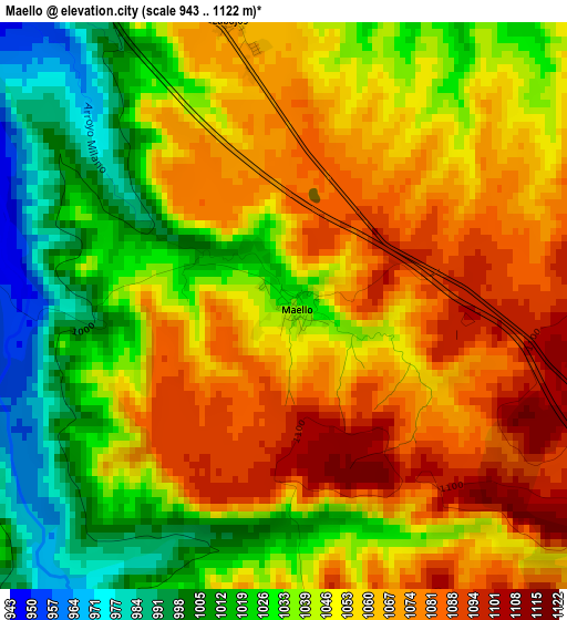
Below is the Elevation map of Maello, which displays elevation range with different colors. Scale of the first map is from 943 to 1122 m (3094 to 3681 ft) with average elevation of 1047.8 meters (=3438 ft) [note 1]
These maps also provides idea of topography and contour of this city, they are displayed at different zoom levels. More info about maps, scale and edge coordinates you can find below images.
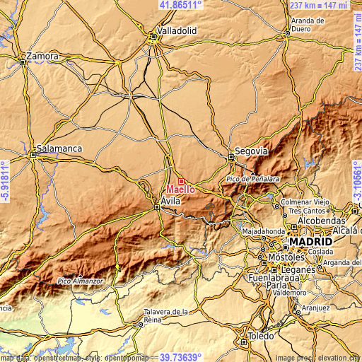
| \ | Map #1 | Topo.Map |
| Scale [m] | 943..1122 m | × |
| Scale [ft] | 3094..3681 ft | × |
| Average | 1047.8 m = 3438 ft | × |
| Width | 7.4 km = 4.6 mi | 236.7 km = 147.1 mi |
| Height | 7.4 km = 4.6 mi | 236.7 km = 147.1 mi |
| ↑Max Latitude | 40.842543° | 41.86511° |
| Latitude at center | 40.80929° | 40.80929° |
| ↓Min Latitude | 40.77602° | 39.73639° |
| ← Min Longitude | -4.555805° | -5.91811° |
| Longitude center | -4.51186° | -4.51186° |
| →Max Longitude | -4.467915° | -3.10561° |
Nearby cities:
Cities around Maello sort by population:
• Villacastín elevation 1103 m
8.9 km,  111°
111°
• Sanchidrián 924 m
11 km,  328°
328°
• Muñopedro 1022 m
9.4 km,  20°
20°
• Velayos 936 m
10 km,  290°
290°
• Labajos 1067 m
3.8 km,  349°
349°
• Vega de Santa María 946 m
11.4 km, 285°
• Bercial 974 m
12.6 km,  30°
30°
• Ituero y Lama 1007 m
11.2 km,  94°
94°
• Tolbaños 1115 m
8.7 km,  222°
222°
• Santo Domingo de las Posadas 926 m
10.3 km,  271°
271°
• Ojos-Albos 1232 m
11.5 km,  181°
181°
• San Esteban de los Patos 1114 m
11.7 km,  233°
233°
Multilingual:
 En español:
Maello elevación 1032 m.
 En France:
Maello élévation 1032 m.


Sources and notes:
- [note 1] Map square and city borders are not equal. Map elevation data is calculated only from area inside that square.
- [src 1] Elevation data from geonames database provided with same terms of usage.
- [src 2] The elevation map of Maello is generated using elevation data from NASA's 3 arcsec (90m) resolution SRTM data.
- [src 3] Base (background) map © OpenStreetMap contributors tiles are generated by Geofabrik and OpenTopoMap.
Copyright & License:
This Maello Elevation Map is licensed under CC BY-SA. You may reuse any part from this page, if you give a proper credit by linking to this URL:
 More info on terms of use page.