Pozanco elevation
Pozanco (Castille and León, Provincia de Ávila), Spain elevation is 911 meters and Pozanco elevation in feet is 2989 ft above sea level [src 1]. Pozanco is a seat of a third-order administrative division (feature code) with elevation that is 308 meters (1010 ft) bigger than average city elevation in Spain.
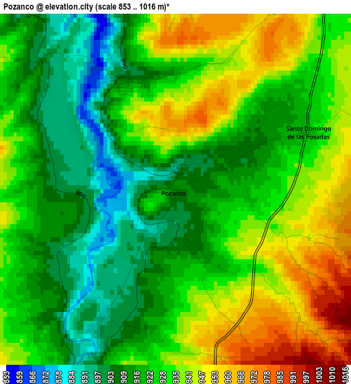
Below is the Elevation map of Pozanco, which displays elevation range with different colors. Scale of the first map is from 853 to 1016 m (2799 to 3333 ft) with average elevation of 926.6 meters (=3040 ft) [note 1]
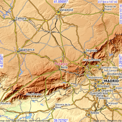
These maps also provides idea of topography and contour of this city, they are displayed at different zoom levels. More info about maps, scale and edge coordinates you can find below images.
| \ | Map #1 | Topo.Map |
| Scale [m] | 853..1016 m | × |
| Scale [ft] | 2799..3333 ft | × |
| Average | 926.6 m = 3040 ft | × |
| Width | 7.4 km = 4.6 mi | 236.7 km = 147.1 mi |
| Height | 7.4 km = 4.6 mi | 236.7 km = 147.1 mi |
| ↑Max Latitude | 40.834208° | 41.85691° |
| Latitude at center | 40.80095° | 40.80095° |
| ↓Min Latitude | 40.767676° | 39.72792° |
| ← Min Longitude | -4.711665° | -6.07397° |
| Longitude center | -4.66772° | -4.66772° |
| →Max Longitude | -4.623775° | -3.26147° |
Nearby cities:
Cities around Pozanco sort by population:
• Cardeñosa elevation 1108 m
9.3 km,  225°
225°
• Mingorría 1037 m
5.5 km,  178°
178°
• Velayos 936 m
5.9 km,  39°
39°
• Hernansancho 902 m
8.2 km,  320°
320°
• Gotarrendura 930 m
6.8 km,  294°
294°
• Villanueva de Gómez 887 m
10 km,  335°
335°
• Blascosancho 906 m
8.9 km,  16°
16°
• Peñalba de Ávila 1062 m
7.3 km,  244°
244°
• Vega de Santa María 946 m
4.4 km,  28°
28°
• Tolbaños 1115 m
9.1 km,  127°
127°
• Santo Domingo de las Posadas 926 m
3.1 km,  66°
66°
• San Esteban de los Patos 1114 m
7 km,  148°
148°
Multilingual:
 En español:
Pozanco elevación 911 m.
 En France:
Pozanco élévation 911 m.


Sources and notes:
- [note 1] Map square and city borders are not equal. Map elevation data is calculated only from area inside that square.
- [src 1] Elevation data from geonames database provided with same terms of usage.
- [src 2] The elevation map of Pozanco is generated using elevation data from NASA's 3 arcsec (90m) resolution SRTM data.
- [src 3] Base (background) map © OpenStreetMap contributors tiles are generated by Geofabrik and OpenTopoMap.
Copyright & License:
This Pozanco Elevation Map is licensed under CC BY-SA. You may reuse any part from this page, if you give a proper credit by linking to this URL:
 More info on terms of use page.