Umbrías elevation
Umbrías (Castille and León, Provincia de Ávila), Spain elevation is 1088 meters and Umbrías elevation in feet is 3570 ft above sea level [src 1]. Umbrías is a seat of a third-order administrative division (feature code) with elevation that is 485 meters (1591 ft) bigger than average city elevation in Spain.
Below is the Elevation map of Umbrías, which displays elevation range with different colors. Scale of the first map is from 1006 to 1723 m (3301 to 5653 ft) with average elevation of 1208.5 meters (=3965 ft) [note 1]
These maps also provides idea of topography and contour of this city, they are displayed at different zoom levels. More info about maps, scale and edge coordinates you can find below images.
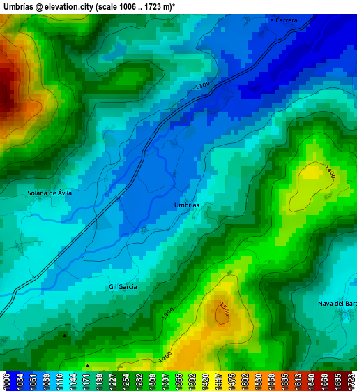
| \ | Map #1 | Topo.Map |
| Scale [m] | 1006..1723 m | × |
| Scale [ft] | 3301..5653 ft | × |
| Average | 1208.5 m = 3965 ft | × |
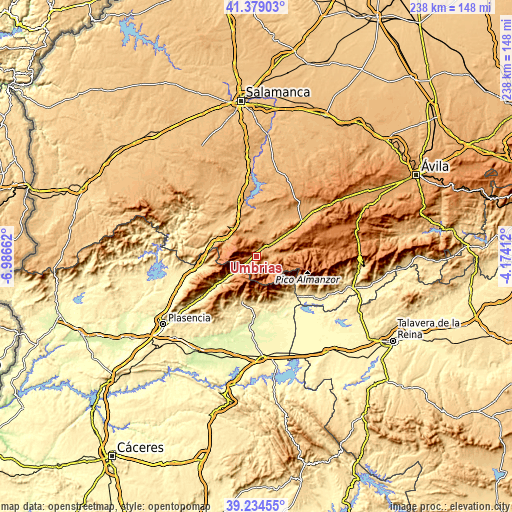
| Width | 7.45 km = 4.6 mi | 238.4 km = 148.1 mi |
| Height | 7.45 km = 4.6 mi | 238.4 km = 148.1 mi |
| ↑Max Latitude | 40.3488° | 41.37903° |
| Latitude at center | 40.3153° | 40.3153° |
| ↓Min Latitude | 40.281784° | 39.23455° |
| ← Min Longitude | -5.624315° | -6.98662° |
| Longitude center | -5.58037° | -5.58037° |
| →Max Longitude | -5.536425° | -4.17412° |
Nearby cities:
Cities around Umbrías sort by population:
• El Barco de Ávila elevation 1019 m
6.7 km,  45°
45°
• Tornavacas 888 m
11.4 km,  233°
233°
• Bohoyo 1141 m
11.7 km,  89°
89°
• Becedas 1106 m
10.9 km,  334°
334°
• Puerto Castilla 1179 m
4.8 km, 230°
• Nava del Barco 1139 m
4.2 km,  125°
125°
• Tormellas 1064 m
5.9 km,  102°
102°
• Junciana 1000 m
10.8 km,  10°
10°
• Navatejares 1048 m
4.7 km,  60°
60°
• San Lorenzo de Tormes 1029 m
9.9 km, 52°
• San Bartolomé de Béjar 1122 m
12.4 km, 325°
• La Carrera 1055 m
4.2 km,  31°
31°
Multilingual:
 En español:
Umbrías elevación 1088 m.
 En France:
Umbrías élévation 1088 m.
 Auf Deutsch:
Umbrías höhe über dem Meeresspiegel ist 1088 m.

Sources and notes:
- [note 1] Map square and city borders are not equal. Map elevation data is calculated only from area inside that square.
- [src 1] Elevation data from geonames database provided with same terms of usage.
- [src 2] The elevation map of Umbrías is generated using elevation data from NASA's 3 arcsec (90m) resolution SRTM data.
- [src 3] Base (background) map © OpenStreetMap contributors tiles are generated by Geofabrik and OpenTopoMap.
Copyright & License:
This Umbrías Elevation Map is licensed under CC BY-SA. You may reuse any part from this page, if you give a proper credit by linking to this URL:
 More info on terms of use page.