Tornavacas elevation
Tornavacas (Extremadura, Provincia de Cáceres), Spain elevation is 888 meters and Tornavacas elevation in feet is 2913 ft above sea level [src 1]. Tornavacas is a seat of a third-order administrative division (feature code) with elevation that is 285 meters (935 ft) bigger than average city elevation in Spain.
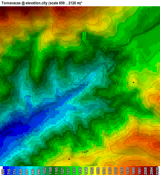
Below is the Elevation map of Tornavacas, which displays elevation range with different colors. Scale of the first map is from 659 to 2120 m (2162 to 6955 ft) with average elevation of 1275.7 meters (=4185 ft) [note 1]
These maps also provides idea of topography and contour of this city, they are displayed at different zoom levels. More info about maps, scale and edge coordinates you can find below images.
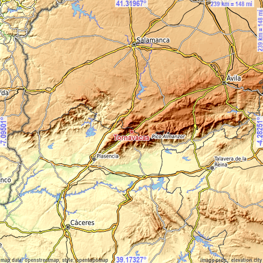
| \ | Map #1 | Topo.Map |
| Scale [m] | 659..2120 m | × |
| Scale [ft] | 2162..6955 ft | × |
| Average | 1275.7 m = 4185 ft | × |
| Width | 7.46 km = 4.6 mi | 238.7 km = 148.3 mi |
| Height | 7.46 km = 4.6 mi | 238.7 km = 148.3 mi |
| ↑Max Latitude | 40.28851° | 41.31967° |
| Latitude at center | 40.25498° | 40.25498° |
| ↓Min Latitude | 40.221434° | 39.17327° |
| ← Min Longitude | -5.732705° | -7.09501° |
| Longitude center | -5.68876° | -5.68876° |
| →Max Longitude | -5.644815° | -4.28251° |
Nearby cities:
Cities around Tornavacas sort by population:
• Hervás elevation 664 m
15.2 km,  276°
276°
• Jarandilla de la Vera 611 m
14.2 km,  170°
170°
• Aldeanueva de la Vera 652 m
14.3 km,  184°
184°
• Cabezuela del Valle 518 m
12.1 km,  235°
235°
• Navaconcejo 462 m
14.9 km,  234°
234°
• Jerte 612 m
6.3 km, 235°
• Candelario 1088 m
13.4 km,  339°
339°
• Guijo de Santa Bárbara 875 m
11.6 km, 165°
• Umbrías 1088 m
11.4 km,  53°
53°
• Puerto Castilla 1179 m
6.6 km,  56°
56°
• Nava del Barco 1139 m
13.3 km,  71°
71°
• La Carrera 1055 m
15.3 km, 47°
Multilingual:
 En español:
Tornavacas elevación 888 m.
 En France:
Tornavacas élévation 888 m.
 Auf Deutsch:
Tornavacas höhe über dem Meeresspiegel ist 888 m.

Sources and notes:
- [note 1] Map square and city borders are not equal. Map elevation data is calculated only from area inside that square.
- [src 1] Elevation data from geonames database provided with same terms of usage.
- [src 2] The elevation map of Tornavacas is generated using elevation data from NASA's 3 arcsec (90m) resolution SRTM data.
- [src 3] Base (background) map © OpenStreetMap contributors tiles are generated by Geofabrik and OpenTopoMap.
Copyright & License:
This Tornavacas Elevation Map is licensed under CC BY-SA. You may reuse any part from this page, if you give a proper credit by linking to this URL:
 More info on terms of use page.