Bohoyo elevation
Bohoyo (Castille and León, Provincia de Ávila), Spain elevation is 1141 meters and Bohoyo elevation in feet is 3743 ft above sea level [src 1]. Bohoyo is a seat of a third-order administrative division (feature code) with elevation that is 538 meters (1765 ft) bigger than average city elevation in Spain.
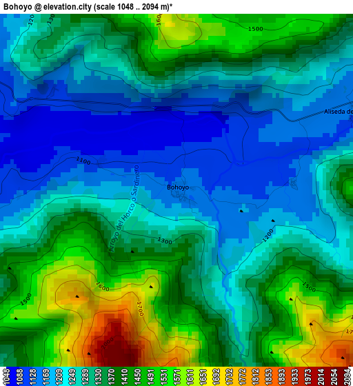
Below is the Elevation map of Bohoyo, which displays elevation range with different colors. Scale of the first map is from 1048 to 2094 m (3438 to 6870 ft) with average elevation of 1323.9 meters (=4344 ft) [note 1]
These maps also provides idea of topography and contour of this city, they are displayed at different zoom levels. More info about maps, scale and edge coordinates you can find below images.
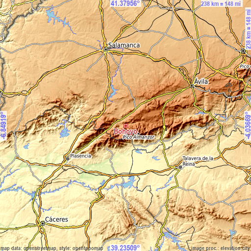
| \ | Map #1 | Topo.Map |
| Scale [m] | 1048..2094 m | × |
| Scale [ft] | 3438..6870 ft | × |
| Average | 1323.9 m = 4344 ft | × |
| Width | 7.45 km = 4.6 mi | 238.4 km = 148.1 mi |
| Height | 7.45 km = 4.6 mi | 238.4 km = 148.1 mi |
| ↑Max Latitude | 40.34934° | 41.37956° |
| Latitude at center | 40.31584° | 40.31584° |
| ↓Min Latitude | 40.282324° | 39.23509° |
| ← Min Longitude | -5.486885° | -6.84919° |
| Longitude center | -5.44294° | -5.44294° |
| →Max Longitude | -5.398995° | -4.03669° |
Nearby cities:
Cities around Bohoyo sort by population:
• El Barco de Ávila elevation 1019 m
8.2 km,  303°
303°
• Aldeanueva de Santa Cruz 1160 m
7.6 km,  13°
13°
• Umbrías 1088 m
11.7 km,  269°
269°
• Nava del Barco 1139 m
8.6 km,  253°
253°
• Navalperal de Tormes 1298 m
12.7 km,  71°
71°
• Zapardiel de la Ribera 1356 m
10.7 km, 65°
• Santa María de los Caballeros 1042 m
8.2 km,  355°
355°
• Tormellas 1064 m
6 km,  257°
257°
• Navatejares 1048 m
7.9 km,  286°
286°
• San Lorenzo de Tormes 1029 m
7.1 km,  327°
327°
• Avellaneda 1353 m
9.4 km,  29°
29°
• La Carrera 1055 m
10.1 km, 290°
Multilingual:
 En español:
Bohoyo elevación 1141 m.
 En France:
Bohoyo élévation 1141 m.


Sources and notes:
- [note 1] Map square and city borders are not equal. Map elevation data is calculated only from area inside that square.
- [src 1] Elevation data from geonames database provided with same terms of usage.
- [src 2] The elevation map of Bohoyo is generated using elevation data from NASA's 3 arcsec (90m) resolution SRTM data.
- [src 3] Base (background) map © OpenStreetMap contributors tiles are generated by Geofabrik and OpenTopoMap.
Copyright & License:
This Bohoyo Elevation Map is licensed under CC BY-SA. You may reuse any part from this page, if you give a proper credit by linking to this URL:
 More info on terms of use page.