Valdeande elevation
Valdeande (Castille and León, Provincia de Burgos), Spain elevation is 951 meters and Valdeande elevation in feet is 3120 ft above sea level [src 1]. Valdeande is a seat of a third-order administrative division (feature code) with elevation that is 348 meters (1142 ft) bigger than average city elevation in Spain.
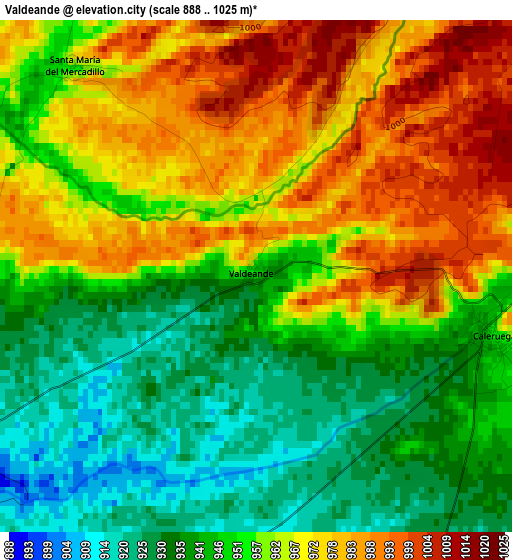
Below is the Elevation map of Valdeande, which displays elevation range with different colors. Scale of the first map is from 888 to 1025 m (2913 to 3363 ft) with average elevation of 957 meters (=3140 ft) [note 1]
These maps also provides idea of topography and contour of this city, they are displayed at different zoom levels. More info about maps, scale and edge coordinates you can find below images.
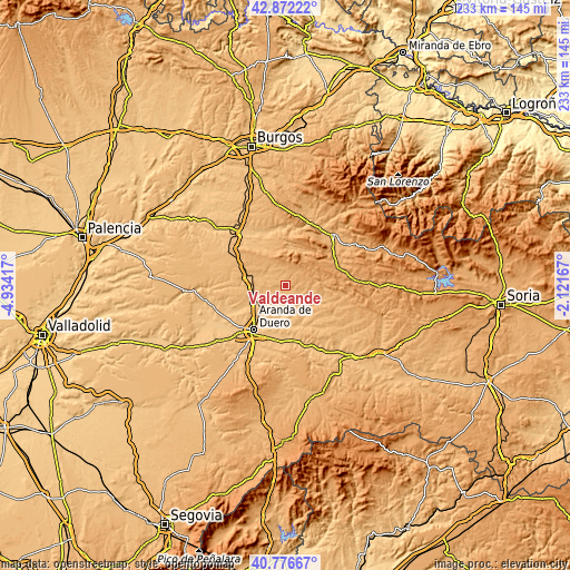
| \ | Map #1 | Topo.Map |
| Scale [m] | 888..1025 m | × |
| Scale [ft] | 2913..3363 ft | × |
| Average | 957 m = 3140 ft | × |
| Width | 7.28 km = 4.5 mi | 233 km = 144.8 mi |
| Height | 7.28 km = 4.5 mi | 233 km = 144.8 mi |
| ↑Max Latitude | 41.865755° | 42.87222° |
| Latitude at center | 41.83302° | 41.83302° |
| ↓Min Latitude | 41.800268° | 40.77667° |
| ← Min Longitude | -3.571865° | -4.93417° |
| Longitude center | -3.52792° | -3.52792° |
| →Max Longitude | -3.483975° | -2.12167° |
Nearby cities:
Cities around Valdeande sort by population:
• Caleruega elevation 969 m
3.6 km,  103°
103°
• Baños de Valdearados 870 m
7.4 km,  198°
198°
• Arauzo de Miel 1000 m
12 km,  76°
76°
• Hontoria de Valdearados 867 m
9.8 km,  176°
176°
• Arandilla 883 m
13.4 km,  142°
142°
• Tubilla del Lago 891 m
6 km,  234°
234°
• Ciruelos de Cervera 1021 m
8.1 km,  358°
358°
• Villalbilla de Gumiel 915 m
8.6 km,  249°
249°
• Arauzo de Torre 920 m
9.5 km,  114°
114°
• Espinosa de Cervera 1031 m
8.6 km,  34°
34°
• Arauzo de Salce 941 m
9.7 km, 99°
• Tejada 1086 m
13.3 km, 357°
Multilingual:
 En español:
Valdeande elevación 951 m.
 En France:
Valdeande élévation 951 m.
 Auf Deutsch:
Valdeande höhe über dem Meeresspiegel ist 951 m.

Sources and notes:
- [note 1] Map square and city borders are not equal. Map elevation data is calculated only from area inside that square.
- [src 1] Elevation data from geonames database provided with same terms of usage.
- [src 2] The elevation map of Valdeande is generated using elevation data from NASA's 3 arcsec (90m) resolution SRTM data.
- [src 3] Base (background) map © OpenStreetMap contributors tiles are generated by Geofabrik and OpenTopoMap.
Copyright & License:
This Valdeande Elevation Map is licensed under CC BY-SA. You may reuse any part from this page, if you give a proper credit by linking to this URL:
 More info on terms of use page.