Arandilla elevation
Arandilla (Castille and León, Provincia de Burgos), Spain elevation is 883 meters and Arandilla elevation in feet is 2897 ft above sea level [src 1]. Arandilla is a seat of a third-order administrative division (feature code) with elevation that is 280 meters (919 ft) bigger than average city elevation in Spain.
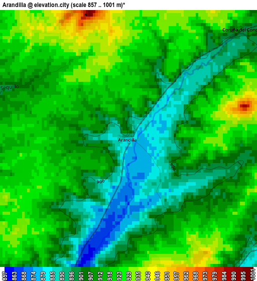
Below is the Elevation map of Arandilla, which displays elevation range with different colors. Scale of the first map is from 857 to 1001 m (2812 to 3284 ft) with average elevation of 912 meters (=2992 ft) [note 1]
These maps also provides idea of topography and contour of this city, they are displayed at different zoom levels. More info about maps, scale and edge coordinates you can find below images.
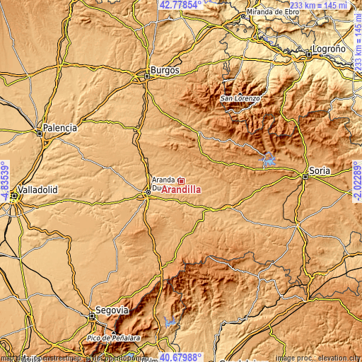
| \ | Map #1 | Topo.Map |
| Scale [m] | 857..1001 m | × |
| Scale [ft] | 2812..3284 ft | × |
| Average | 912 m = 2992 ft | × |
| Width | 7.29 km = 4.5 mi | 233.3 km = 145 mi |
| Height | 7.29 km = 4.5 mi | 233.3 km = 145 mi |
| ↑Max Latitude | 41.770564° | 42.77854° |
| Latitude at center | 41.73778° | 41.73778° |
| ↓Min Latitude | 41.70498° | 40.67988° |
| ← Min Longitude | -3.473085° | -4.83539° |
| Longitude center | -3.42914° | -3.42914° |
| →Max Longitude | -3.385195° | -2.02289° |
Nearby cities:
Cities around Arandilla sort by population:
• Peñaranda de Duero elevation 858 m
6.8 km,  216°
216°
• Caleruega 969 m
10.8 km,  334°
334°
• Baños de Valdearados 870 m
11.1 km,  288°
288°
• Zazuar 832 m
11.4 km,  245°
245°
• Quemada 850 m
12.8 km, 251°
• Hontoria de Valdearados 867 m
7.6 km,  275°
275°
• Alcubilla de Avellaneda 930 m
10.4 km,  97°
97°
• San Juan del Monte 844 m
9.9 km,  232°
232°
• Coruña del Conde 900 m
4.5 km,  45°
45°
• Arauzo de Torre 920 m
6.7 km,  4°
4°
• Brazacorta 912 m
5.6 km,  113°
113°
• Arauzo de Salce 941 m
9.2 km,  8°
8°
Multilingual:
 En español:
Arandilla elevación 883 m.
 En France:
Arandilla élévation 883 m.
 Auf Deutsch:
Arandilla höhe über dem Meeresspiegel ist 883 m.

Sources and notes:
- [note 1] Map square and city borders are not equal. Map elevation data is calculated only from area inside that square.
- [src 1] Elevation data from geonames database provided with same terms of usage.
- [src 2] The elevation map of Arandilla is generated using elevation data from NASA's 3 arcsec (90m) resolution SRTM data.
- [src 3] Base (background) map © OpenStreetMap contributors tiles are generated by Geofabrik and OpenTopoMap.
Copyright & License:
This Arandilla Elevation Map is licensed under CC BY-SA. You may reuse any part from this page, if you give a proper credit by linking to this URL:
 More info on terms of use page.