Valdepiélagos elevation
Valdepiélagos (Madrid, Provincia de Madrid), Spain elevation is 752 meters and Valdepiélagos elevation in feet is 2467 ft above sea level [src 1]. Valdepiélagos is a seat of a third-order administrative division (feature code) with elevation that is 149 meters (489 ft) bigger than average city elevation in Spain.
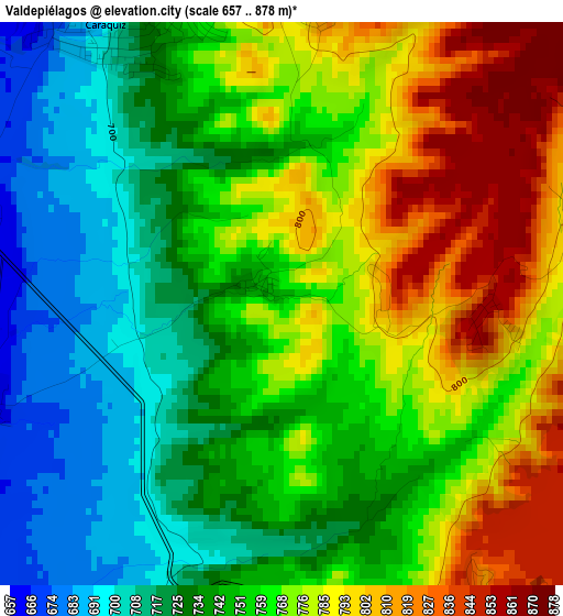
Below is the Elevation map of Valdepiélagos, which displays elevation range with different colors. Scale of the first map is from 657 to 878 m (2156 to 2881 ft) with average elevation of 755.7 meters (=2479 ft) [note 1]
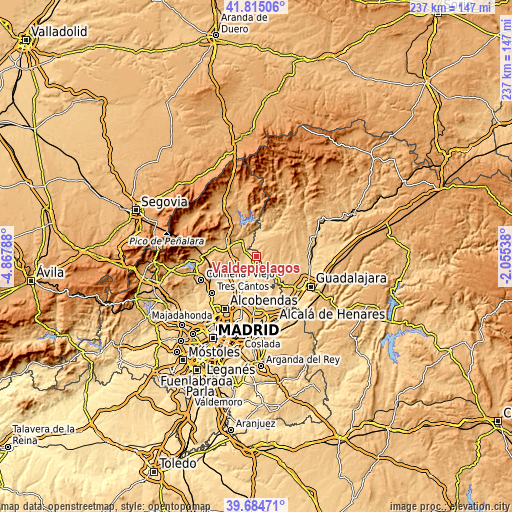
These maps also provides idea of topography and contour of this city, they are displayed at different zoom levels. More info about maps, scale and edge coordinates you can find below images.
| \ | Map #1 | Topo.Map |
| Scale [m] | 657..878 m | × |
| Scale [ft] | 2156..2881 ft | × |
| Average | 755.7 m = 2479 ft | × |
| Width | 7.4 km = 4.6 mi | 236.9 km = 147.2 mi |
| Height | 7.4 km = 4.6 mi | 236.9 km = 147.2 mi |
| ↑Max Latitude | 40.791699° | 41.81506° |
| Latitude at center | 40.75842° | 40.75842° |
| ↓Min Latitude | 40.725124° | 39.68471° |
| ← Min Longitude | -3.505575° | -4.86788° |
| Longitude center | -3.46163° | -3.46163° |
| →Max Longitude | -3.417685° | -2.05538° |
Nearby cities:
Cities around Valdepiélagos sort by population:
• El Molar elevation 839 m
10.4 km,  253°
253°
• Torrelaguna 736 m
10 km,  320°
320°
• Valdetorres de Jarama 655 m
8.3 km,  210°
210°
• Pedrezuela 874 m
11.8 km,  261°
261°
• Talamanca de Jarama 655 m
4.3 km, 247°
• Uceda 785 m
9 km,  0°
0°
• El Vellón 873 m
10 km,  274°
274°
• Torremocha de Jarama 715 m
9.7 km,  342°
342°
• Patones 714 m
11 km,  349°
349°
• Viñuelas 868 m
10.9 km,  69°
69°
• Casa de Uceda 917 m
12.1 km,  40°
40°
• Villaseca de Uceda 899 m
11.6 km,  54°
54°
Multilingual:
 En español:
Valdepiélagos elevación 752 m.
 En France:
Valdepiélagos élévation 752 m.
 Auf Deutsch:
Valdepiélagos höhe über dem Meeresspiegel ist 752 m.

Sources and notes:
- [note 1] Map square and city borders are not equal. Map elevation data is calculated only from area inside that square.
- [src 1] Elevation data from geonames database provided with same terms of usage.
- [src 2] The elevation map of Valdepiélagos is generated using elevation data from NASA's 3 arcsec (90m) resolution SRTM data.
- [src 3] Base (background) map © OpenStreetMap contributors tiles are generated by Geofabrik and OpenTopoMap.
Copyright & License:
This Valdepiélagos Elevation Map is licensed under CC BY-SA. You may reuse any part from this page, if you give a proper credit by linking to this URL:
 More info on terms of use page.