Casa de Uceda elevation
Casa de Uceda (Castille-La Mancha, Provincia de Guadalajara), Spain elevation is 917 meters and Casa de Uceda elevation in feet is 3009 ft above sea level [src 1]. Casa de Uceda is a seat of a third-order administrative division (feature code) with elevation that is 314 meters (1030 ft) bigger than average city elevation in Spain.
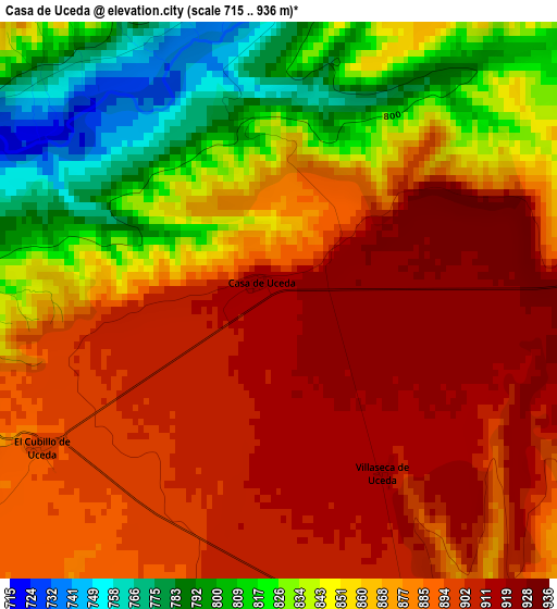
Below is the Elevation map of Casa de Uceda, which displays elevation range with different colors. Scale of the first map is from 715 to 936 m (2346 to 3071 ft) with average elevation of 868.9 meters (=2851 ft) [note 1]
These maps also provides idea of topography and contour of this city, they are displayed at different zoom levels. More info about maps, scale and edge coordinates you can find below images.
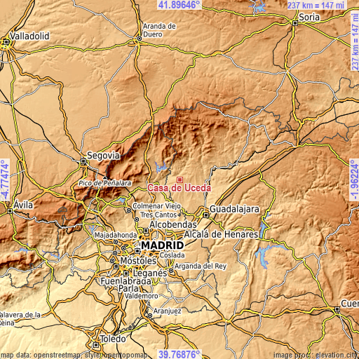
| \ | Map #1 | Topo.Map |
| Scale [m] | 715..936 m | × |
| Scale [ft] | 2346..3071 ft | × |
| Average | 868.9 m = 2851 ft | × |
| Width | 7.39 km = 4.6 mi | 236.6 km = 147 mi |
| Height | 7.39 km = 4.6 mi | 236.6 km = 147 mi |
| ↑Max Latitude | 40.874387° | 41.89646° |
| Latitude at center | 40.84115° | 40.84115° |
| ↓Min Latitude | 40.807896° | 39.76876° |
| ← Min Longitude | -3.412435° | -4.77474° |
| Longitude center | -3.36849° | -3.36849° |
| →Max Longitude | -3.324545° | -1.96224° |
Nearby cities:
Cities around Casa de Uceda sort by population:
• Uceda elevation 785 m
7.7 km,  268°
268°
• Torremocha de Jarama 715 m
10.8 km, 270°
• Patones 714 m
9.9 km,  279°
279°
• Málaga del Fresno 773 m
12 km,  119°
119°
• Valdepeñas de la Sierra 844 m
7.3 km,  349°
349°
• Fuentelahiguera de Albatages 877 m
8.4 km,  140°
140°
• Malaguilla 812 m
9.9 km,  104°
104°
• Robledillo de Mohernando 874 m
11.6 km,  84°
84°
• Viñuelas 868 m
5.9 km,  156°
156°
• Villaseca de Uceda 899 m
3 km,  147°
147°
• Matarrubia 877 m
7.1 km,  68°
68°
• Tortuero 943 m
10.5 km,  8°
8°
Multilingual:
 En español:
Casa de Uceda elevación 917 m.
 En France:
Casa de Uceda élévation 917 m.
 Auf Deutsch:
Casa de Uceda höhe über dem Meeresspiegel ist 917 m.

Sources and notes:
- [note 1] Map square and city borders are not equal. Map elevation data is calculated only from area inside that square.
- [src 1] Elevation data from geonames database provided with same terms of usage.
- [src 2] The elevation map of Casa de Uceda is generated using elevation data from NASA's 3 arcsec (90m) resolution SRTM data.
- [src 3] Base (background) map © OpenStreetMap contributors tiles are generated by Geofabrik and OpenTopoMap.
Copyright & License:
This Casa de Uceda Elevation Map is licensed under CC BY-SA. You may reuse any part from this page, if you give a proper credit by linking to this URL:
 More info on terms of use page.