Valdeprado elevation
Valdeprado (Castille and León, Provincia de Soria), Spain elevation is 841 meters and Valdeprado elevation in feet is 2759 ft above sea level [src 1]. Valdeprado is a seat of a third-order administrative division (feature code) with elevation that is 238 meters (781 ft) bigger than average city elevation in Spain.
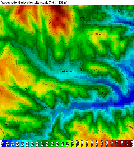
Below is the Elevation map of Valdeprado, which displays elevation range with different colors. Scale of the first map is from 746 to 1236 m (2448 to 4055 ft) with average elevation of 940.8 meters (=3087 ft) [note 1]
These maps also provides idea of topography and contour of this city, they are displayed at different zoom levels. More info about maps, scale and edge coordinates you can find below images.
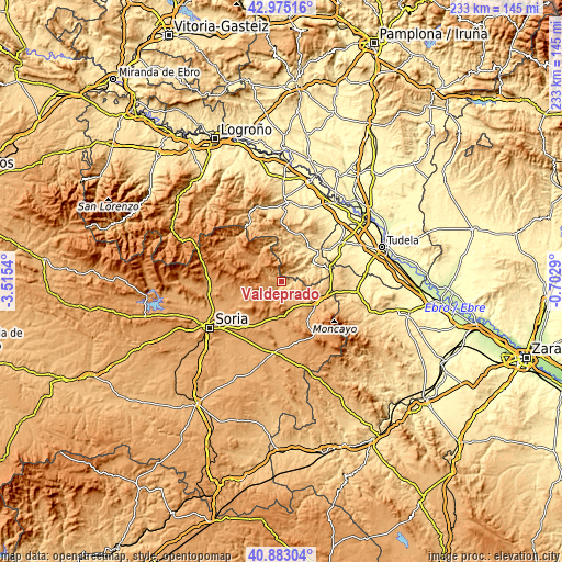
| \ | Map #1 | Topo.Map |
| Scale [m] | 746..1236 m | × |
| Scale [ft] | 2448..4055 ft | × |
| Average | 940.8 m = 3087 ft | × |
| Width | 7.27 km = 4.5 mi | 232.6 km = 144.5 mi |
| Height | 7.27 km = 4.5 mi | 232.6 km = 144.5 mi |
| ↑Max Latitude | 41.970361° | 42.97516° |
| Latitude at center | 41.93768° | 41.93768° |
| ↓Min Latitude | 41.904982° | 40.88304° |
| ← Min Longitude | -2.153095° | -3.5154° |
| Longitude center | -2.10915° | -2.10915° |
| →Max Longitude | -2.065205° | -0.7029° |
Nearby cities:
Cities around Valdeprado sort by population:
• Aguilar del Río Alhama elevation 634 m
10 km,  74°
74°
• Castilruiz 1012 m
7.9 km,  148°
148°
• Magaña 937 m
6 km,  227°
227°
• Fuentestrún 1012 m
7.3 km,  162°
162°
• Fuentes de Magaña 1148 m
5.8 km,  267°
267°
• Cigudosa 776 m
4.9 km,  95°
95°
• Cerbón 1116 m
5 km,  259°
259°
• Valtajeros 1256 m
9.4 km, 270°
• Navajún 955 m
3.3 km,  13°
13°
• Valdelagua del Cerro 1120 m
5.5 km,  185°
185°
• Valdemadera 973 m
5.9 km,  29°
29°
• San Felices 940 m
6.8 km,  90°
90°
Multilingual:
 En español:
Valdeprado elevación 841 m.
 En France:
Valdeprado élévation 841 m.
 Auf Deutsch:
Valdeprado höhe über dem Meeresspiegel ist 841 m.

Sources and notes:
- [note 1] Map square and city borders are not equal. Map elevation data is calculated only from area inside that square.
- [src 1] Elevation data from geonames database provided with same terms of usage.
- [src 2] The elevation map of Valdeprado is generated using elevation data from NASA's 3 arcsec (90m) resolution SRTM data.
- [src 3] Base (background) map © OpenStreetMap contributors tiles are generated by Geofabrik and OpenTopoMap.
Copyright & License:
This Valdeprado Elevation Map is licensed under CC BY-SA. You may reuse any part from this page, if you give a proper credit by linking to this URL:
 More info on terms of use page.