Valtajeros elevation
Valtajeros (Castille and León, Provincia de Soria), Spain elevation is 1256 meters and Valtajeros elevation in feet is 4121 ft above sea level [src 1]. Valtajeros is a seat of a third-order administrative division (feature code) with elevation that is 653 meters (2142 ft) bigger than average city elevation in Spain.
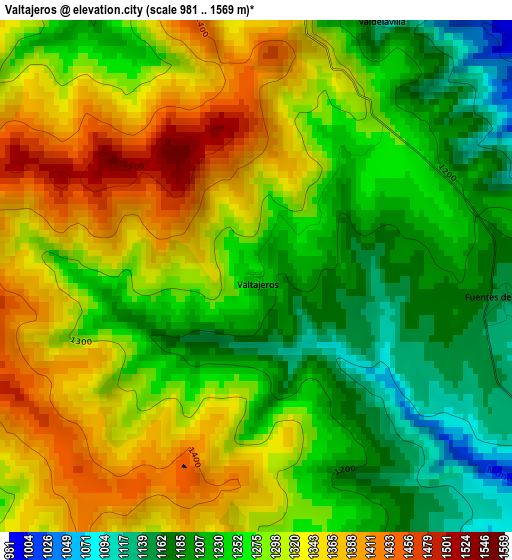
Below is the Elevation map of Valtajeros, which displays elevation range with different colors. Scale of the first map is from 981 to 1569 m (3219 to 5148 ft) with average elevation of 1278.4 meters (=4194 ft) [note 1]
These maps also provides idea of topography and contour of this city, they are displayed at different zoom levels. More info about maps, scale and edge coordinates you can find below images.

| \ | Map #1 | Topo.Map |
| Scale [m] | 981..1569 m | × |
| Scale [ft] | 3219..5148 ft | × |
| Average | 1278.4 m = 4194 ft | × |
| Width | 7.27 km = 4.5 mi | 232.6 km = 144.5 mi |
| Height | 7.27 km = 4.5 mi | 232.6 km = 144.5 mi |
| ↑Max Latitude | 41.970761° | 42.97555° |
| Latitude at center | 41.93808° | 41.93808° |
| ↓Min Latitude | 41.905382° | 40.88345° |
| ← Min Longitude | -2.266835° | -3.62914° |
| Longitude center | -2.22289° | -2.22289° |
| →Max Longitude | -2.178945° | -0.81664° |
Nearby cities:
Cities around Valtajeros sort by population:
• San Pedro Manrique elevation 1081 m
10.1 km,  356°
356°
• Oncala 1304 m
8.4 km,  295°
295°
• Magaña 937 m
6.5 km,  129°
129°
• Fuentes de Magaña 1148 m
3.6 km,  95°
95°
• Aldealseñor 1091 m
10.1 km,  229°
229°
• Cerbón 1116 m
4.6 km, 102°
• Suellacabras 1200 m
9.5 km,  180°
180°
• Castilfrío de la Sierra 1201 m
7.1 km,  252°
252°
• Valdeprado 841 m
9.4 km,  90°
90°
• Valdelagua del Cerro 1120 m
10.5 km,  121°
121°
• Carrascosa de la Sierra 1186 m
6.7 km,  224°
224°
• Estepa de San Juan 1253 m
9.2 km,  262°
262°
Multilingual:
 En español:
Valtajeros elevación 1256 m.
 En France:
Valtajeros élévation 1256 m.
 Auf Deutsch:
Valtajeros höhe über dem Meeresspiegel ist 1256 m.

Sources and notes:
- [note 1] Map square and city borders are not equal. Map elevation data is calculated only from area inside that square.
- [src 1] Elevation data from geonames database provided with same terms of usage.
- [src 2] The elevation map of Valtajeros is generated using elevation data from NASA's 3 arcsec (90m) resolution SRTM data.
- [src 3] Base (background) map © OpenStreetMap contributors tiles are generated by Geofabrik and OpenTopoMap.
Copyright & License:
This Valtajeros Elevation Map is licensed under CC BY-SA. You may reuse any part from this page, if you give a proper credit by linking to this URL:
 More info on terms of use page.