Aguilar del Río Alhama elevation
Aguilar del Río Alhama (La Rioja, Provincia de La Rioja), Spain elevation is 634 meters and Aguilar del Río Alhama elevation in feet is 2080 ft above sea level [src 1]. Aguilar del Río Alhama is a seat of a third-order administrative division (feature code) with elevation that is 31 meters (102 ft) bigger than average city elevation in Spain.
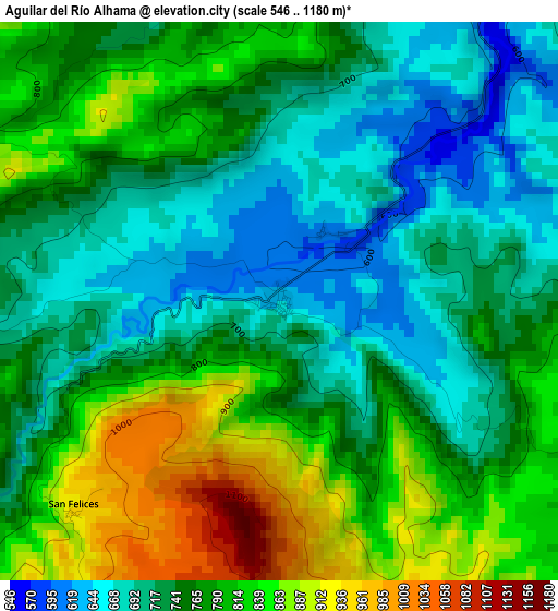
Below is the Elevation map of Aguilar del Río Alhama, which displays elevation range with different colors. Scale of the first map is from 546 to 1180 m (1791 to 3871 ft) with average elevation of 765.3 meters (=2511 ft) [note 1]
These maps also provides idea of topography and contour of this city, they are displayed at different zoom levels. More info about maps, scale and edge coordinates you can find below images.
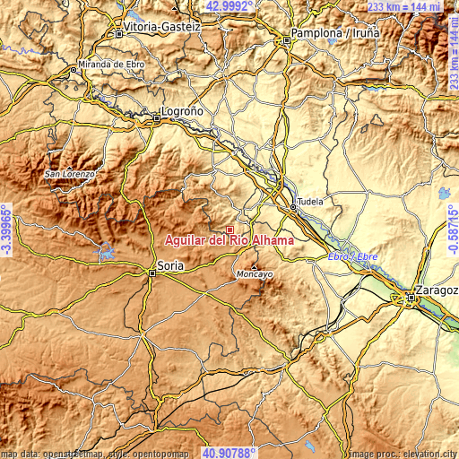
| \ | Map #1 | Topo.Map |
| Scale [m] | 546..1180 m | × |
| Scale [ft] | 1791..3871 ft | × |
| Average | 765.3 m = 2511 ft | × |
| Width | 7.27 km = 4.5 mi | 232.5 km = 144.5 mi |
| Height | 7.27 km = 4.5 mi | 232.5 km = 144.5 mi |
| ↑Max Latitude | 41.994789° | 42.9992° |
| Latitude at center | 41.96212° | 41.96212° |
| ↓Min Latitude | 41.929434° | 40.90788° |
| ← Min Longitude | -2.037345° | -3.39965° |
| Longitude center | -1.9934° | -1.9934° |
| →Max Longitude | -1.949455° | -0.58715° |
Nearby cities:
Cities around Aguilar del Río Alhama sort by population:
• Ágreda elevation 958 m
13.2 km,  153°
153°
• Cervera del Río Alhama 539 m
5.7 km,  33°
33°
• Igea 570 m
11.8 km,  352°
352°
• Castilruiz 1012 m
10.9 km,  209°
209°
• Matalebreras 996 m
14.1 km,  198°
198°
• Fuentestrún 1012 m
12.2 km,  217°
217°
• Cigudosa 776 m
5.7 km,  235°
235°
• Valdeprado 841 m
10 km,  254°
254°
• Navajún 955 m
8.8 km,  273°
273°
• Valdelagua del Cerro 1120 m
13 km,  230°
230°
• Valdemadera 973 m
7.1 km,  290°
290°
• San Felices 940 m
3.9 km, 224°
Multilingual:
 En español:
Aguilar del Río Alhama elevación 634 m.
 En France:
Aguilar del Río Alhama élévation 634 m.
 Auf Deutsch:
Aguilar del Río Alhama höhe über dem Meeresspiegel ist 634 m.
 На русском:
Агилар-дель-Рио-Алама высота над уровнем моря 634 м
Sources and notes:
- [note 1] Map square and city borders are not equal. Map elevation data is calculated only from area inside that square.
- [src 1] Elevation data from geonames database provided with same terms of usage.
- [src 2] The elevation map of Aguilar del Río Alhama is generated using elevation data from NASA's 3 arcsec (90m) resolution SRTM data.
- [src 3] Base (background) map © OpenStreetMap contributors tiles are generated by Geofabrik and OpenTopoMap.
Copyright & License:
This Aguilar del Río Alhama Elevation Map is licensed under CC BY-SA. You may reuse any part from this page, if you give a proper credit by linking to this URL:
 More info on terms of use page.