Valluércanes elevation
Valluércanes (Castille and León, Provincia de Burgos), Spain elevation is 719 meters and Valluércanes elevation in feet is 2359 ft above sea level [src 1]. Valluércanes is a seat of a third-order administrative division (feature code) with elevation that is 116 meters (381 ft) bigger than average city elevation in Spain.
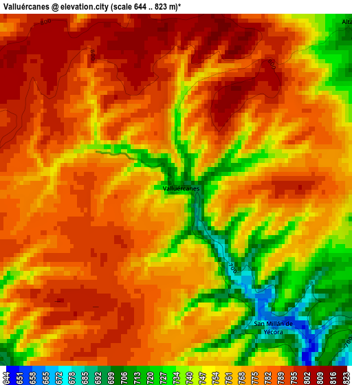
Below is the Elevation map of Valluércanes, which displays elevation range with different colors. Scale of the first map is from 644 to 823 m (2113 to 2700 ft) with average elevation of 767.1 meters (=2517 ft) [note 1]
These maps also provides idea of topography and contour of this city, they are displayed at different zoom levels. More info about maps, scale and edge coordinates you can find below images.
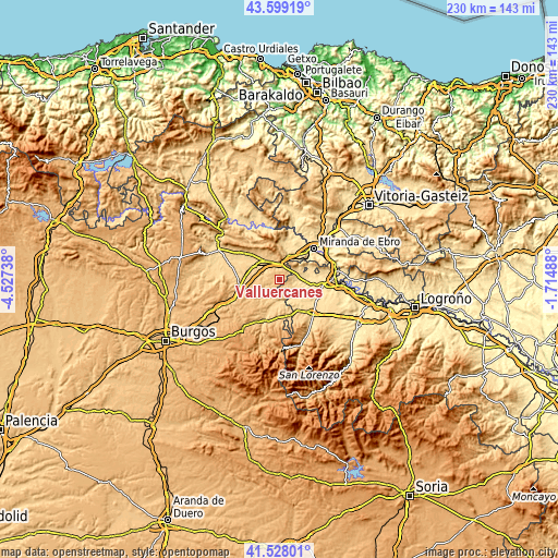
| \ | Map #1 | Topo.Map |
| Scale [m] | 644..823 m | × |
| Scale [ft] | 2113..2700 ft | × |
| Average | 767.1 m = 2517 ft | × |
| Width | 7.2 km = 4.5 mi | 230.3 km = 143.1 mi |
| Height | 7.2 km = 4.5 mi | 230.3 km = 143.1 mi |
| ↑Max Latitude | 42.604554° | 43.59919° |
| Latitude at center | 42.5722° | 42.5722° |
| ↓Min Latitude | 42.539829° | 41.52801° |
| ← Min Longitude | -3.165075° | -4.52738° |
| Longitude center | -3.12113° | -3.12113° |
| →Max Longitude | -3.077185° | -1.71488° |
Nearby cities:
Cities around Valluércanes sort by population:
• Pancorbo elevation 641 m
6.9 km,  6°
6°
• Leiva 590 m
9.8 km,  141°
141°
• Treviana 581 m
6 km,  104°
104°
• Tormantos 612 m
9.5 km,  156°
156°
• Fonzaleche 555 m
9 km,  83°
83°
• Foncea 694 m
8.3 km,  54°
54°
• San Millán de Yécora 658 m
3.4 km, 144°
• Zuñeda 717 m
9.4 km,  292°
292°
• Vallarta de Bureba 709 m
7.1 km,  284°
284°
• Altable 710 m
4.9 km, 46°
• Villanueva de Teba 725 m
9.2 km,  338°
338°
• Cerezo de Río Tirón 661 m
9.1 km,  187°
187°
Multilingual:
 En español:
Valluércanes elevación 719 m.
 En France:
Valluércanes élévation 719 m.
 Auf Deutsch:
Valluércanes höhe über dem Meeresspiegel ist 719 m.

Sources and notes:
- [note 1] Map square and city borders are not equal. Map elevation data is calculated only from area inside that square.
- [src 1] Elevation data from geonames database provided with same terms of usage.
- [src 2] The elevation map of Valluércanes is generated using elevation data from NASA's 3 arcsec (90m) resolution SRTM data.
- [src 3] Base (background) map © OpenStreetMap contributors tiles are generated by Geofabrik and OpenTopoMap.
Copyright & License:
This Valluércanes Elevation Map is licensed under CC BY-SA. You may reuse any part from this page, if you give a proper credit by linking to this URL:
 More info on terms of use page.