Zuñeda elevation
Zuñeda (Castille and León, Provincia de Burgos), Spain elevation is 717 meters and Zuñeda elevation in feet is 2352 ft above sea level [src 1]. Zuñeda is a seat of a third-order administrative division (feature code) with elevation that is 114 meters (374 ft) bigger than average city elevation in Spain.
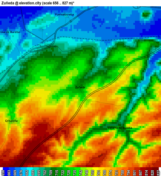
Below is the Elevation map of Zuñeda, which displays elevation range with different colors. Scale of the first map is from 656 to 827 m (2152 to 2713 ft) with average elevation of 732.7 meters (=2404 ft) [note 1]
These maps also provides idea of topography and contour of this city, they are displayed at different zoom levels. More info about maps, scale and edge coordinates you can find below images.

| \ | Map #1 | Topo.Map |
| Scale [m] | 656..827 m | × |
| Scale [ft] | 2152..2713 ft | × |
| Average | 732.7 m = 2404 ft | × |
| Width | 7.19 km = 4.5 mi | 230.2 km = 143 mi |
| Height | 7.19 km = 4.5 mi | 230.2 km = 143 mi |
| ↑Max Latitude | 42.637347° | 43.63146° |
| Latitude at center | 42.60501° | 42.60501° |
| ↓Min Latitude | 42.572656° | 41.56137° |
| ← Min Longitude | -3.270265° | -4.63257° |
| Longitude center | -3.22632° | -3.22632° |
| →Max Longitude | -3.182375° | -1.82007° |
Nearby cities:
Cities around Zuñeda sort by population:
• Busto de Bureba elevation 707 m
6.8 km,  332°
332°
• Cubo de Bureba 685 m
4.2 km,  22°
22°
• Miraveche 806 m
8 km, 15°
• Quintanaélez 709 m
9.3 km,  320°
320°
• Fuentebureba 680 m
3.3 km,  347°
347°
• Aguilar de Bureba 690 m
8.6 km,  258°
258°
• Vallarta de Bureba 709 m
2.5 km,  135°
135°
• Villanueva de Teba 725 m
7.1 km,  46°
46°
• Cascajares de Bureba 804 m
8.3 km, 353°
• Berzosa de Bureba 676 m
4.1 km,  306°
306°
• Grisaleña 743 m
3.5 km,  243°
243°
• Vileña 667 m
8.1 km,  283°
283°
Multilingual:
 En español:
Zuñeda elevación 717 m.
 En France:
Zuñeda élévation 717 m.


Sources and notes:
- [note 1] Map square and city borders are not equal. Map elevation data is calculated only from area inside that square.
- [src 1] Elevation data from geonames database provided with same terms of usage.
- [src 2] The elevation map of Zuñeda is generated using elevation data from NASA's 3 arcsec (90m) resolution SRTM data.
- [src 3] Base (background) map © OpenStreetMap contributors tiles are generated by Geofabrik and OpenTopoMap.
Copyright & License:
This Zuñeda Elevation Map is licensed under CC BY-SA. You may reuse any part from this page, if you give a proper credit by linking to this URL:
 More info on terms of use page.