Zambrana elevation
Zambrana (Basque Country, Araba / Álava), Spain elevation is 457 meters and Zambrana elevation in feet is 1499 ft above sea level [src 1]. Zambrana is a seat of a third-order administrative division (feature code) with elevation that is 146 meters (479 ft) smaller than average city elevation in Spain.
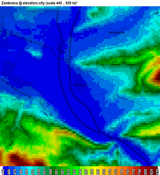
Below is the Elevation map of Zambrana, which displays elevation range with different colors. Scale of the first map is from 445 to 839 m (1460 to 2753 ft) with average elevation of 516.2 meters (=1694 ft) [note 1]
These maps also provides idea of topography and contour of this city, they are displayed at different zoom levels. More info about maps, scale and edge coordinates you can find below images.
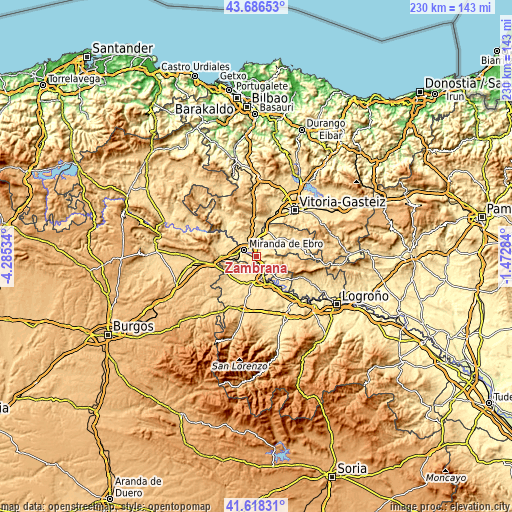
| \ | Map #1 | Topo.Map |
| Scale [m] | 445..839 m | × |
| Scale [ft] | 1460..2753 ft | × |
| Average | 516.2 m = 1694 ft | × |
| Width | 7.19 km = 4.5 mi | 230 km = 142.9 mi |
| Height | 7.19 km = 4.5 mi | 230 km = 142.9 mi |
| ↑Max Latitude | 42.693328° | 43.68653° |
| Latitude at center | 42.66102° | 42.66102° |
| ↓Min Latitude | 42.628695° | 41.61831° |
| ← Min Longitude | -2.923035° | -4.28534° |
| Longitude center | -2.87909° | -2.87909° |
| →Max Longitude | -2.835145° | -1.47284° |
Nearby cities:
Cities around Zambrana sort by population:
• Miranda de Ebro elevation 466 m
6.2 km,  297°
297°
• Haro 478 m
9.8 km,  164°
164°
• Bastida / Labastida 532 m
10.5 km,  139°
139°
• Berantevilla 473 m
2.9 km,  35°
35°
• Anguciana 474 m
9.8 km,  190°
190°
• Briñas 451 m
7.7 km,  149°
149°
• Villalba de Rioja 571 m
5.7 km, 186°
• Cihuri 487 m
11.3 km,  198°
198°
• Armiñón 467 m
6.9 km,  4°
4°
• Sajazarra 521 m
10.5 km,  219°
219°
• Galbárruli 651 m
8 km,  236°
236°
• Cellorigo 768 m
10.6 km,  249°
249°
Multilingual:
 En español:
Zambrana elevación 457 m.
 En France:
Zambrana élévation 457 m.
 Auf Deutsch:
Zambrana höhe über dem Meeresspiegel ist 457 m.

Sources and notes:
- [note 1] Map square and city borders are not equal. Map elevation data is calculated only from area inside that square.
- [src 1] Elevation data from geonames database provided with same terms of usage.
- [src 2] The elevation map of Zambrana is generated using elevation data from NASA's 3 arcsec (90m) resolution SRTM data.
- [src 3] Base (background) map © OpenStreetMap contributors tiles are generated by Geofabrik and OpenTopoMap.
Copyright & License:
This Zambrana Elevation Map is licensed under CC BY-SA. You may reuse any part from this page, if you give a proper credit by linking to this URL:
 More info on terms of use page.