Haro elevation
Haro (La Rioja, Provincia de La Rioja), Spain elevation is 478 meters and Haro elevation in feet is 1568 ft above sea level [src 1]. Haro is a seat of a third-order administrative division (feature code) with elevation that is 125 meters (410 ft) smaller than average city elevation in Spain.
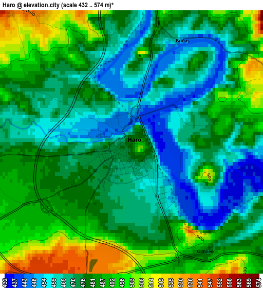
Below is the Elevation map of Haro, which displays elevation range with different colors. Scale of the first map is from 432 to 574 m (1417 to 1883 ft) with average elevation of 477.9 meters (=1568 ft) [note 1]
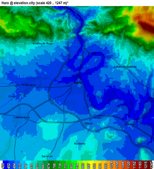
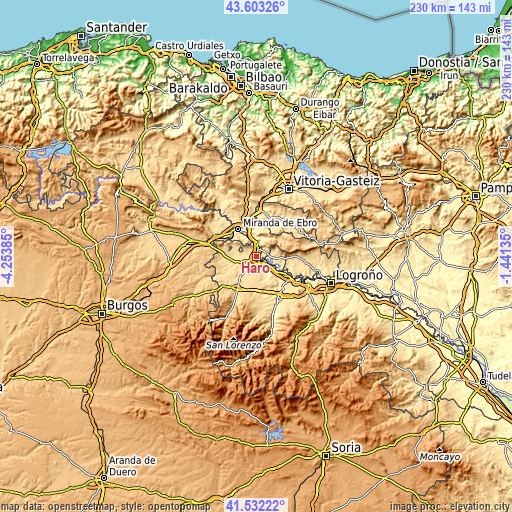
These maps also provides idea of topography and contour of this city, they are displayed at different zoom levels. More info about maps, scale and edge coordinates you can find below images.
| \ | Map #1 | Map #2 | Topo.Map |
| Scale [m] | 432..574 m | 420..1247 m | × |
| Scale [ft] | 1417..1883 ft | 1378..4091 ft | × |
| Average | 477.9 m = 1568 ft | 548 m = 1798 ft | × |
| Width | 7.2 km = 4.5 mi | 14.39 km = 8.9 mi | 230.3 km = 143.1 mi |
| Height | 7.2 km = 4.5 mi | 14.39 km = 8.9 mi | 230.3 km = 143.1 mi |
| ↑Max Latitude | 42.608692° | 42.641027° | 43.60326° |
| Latitude at center | 42.57634° | 42.57634° | 42.57634° |
| ↓Min Latitude | 42.543971° | 42.511586° | 41.53222° |
| ← Min Longitude | -2.891545° | -2.935491° | -4.25385° |
| Longitude center | -2.8476° | -2.8476° | -2.8476° |
| →Max Longitude | -2.803655° | -2.759709° | -1.44135° |
Nearby cities:
Cities around Haro sort by population:
• Bastida / Labastida elevation 532 m
4.5 km,  70°
70°
• Casalarreina 502 m
5.9 km,  239°
239°
• San Vicente de la Sonsierra 489 m
7.3 km,  101°
101°
• Briones 505 m
6.2 km,  125°
125°
• Rodezno 548 m
5.6 km,  178°
178°
• Anguciana 474 m
4.4 km,  266°
266°
• Ollauri 497 m
3.9 km,  164°
164°
• Zarratón 557 m
7.2 km,  202°
202°
• Briñas 451 m
3 km,  25°
25°
• Villalba de Rioja 571 m
4.9 km,  319°
319°
• Cihuri 487 m
6.3 km,  258°
258°
• Gimileo 482 m
3.6 km,  144°
144°
Multilingual:
 En español:
Haro elevación 478 m.
 En France:
Haro élévation 478 m.


Sources and notes:
- [note 1] Map square and city borders are not equal. Map elevation data is calculated only from area inside that square.
- [src 1] Elevation data from geonames database provided with same terms of usage.
- [src 2] The elevation map of Haro is generated using elevation data from NASA's 3 arcsec (90m) resolution SRTM data.
- [src 3] Base (background) map © OpenStreetMap contributors tiles are generated by Geofabrik and OpenTopoMap.
Copyright & License:
This Haro Elevation Map is licensed under CC BY-SA. You may reuse any part from this page, if you give a proper credit by linking to this URL:
 More info on terms of use page.