Sajazarra elevation
Sajazarra (La Rioja, Provincia de La Rioja), Spain elevation is 521 meters and Sajazarra elevation in feet is 1709 ft above sea level [src 1]. Sajazarra is a seat of a third-order administrative division (feature code) with elevation that is 82 meters (269 ft) smaller than average city elevation in Spain.
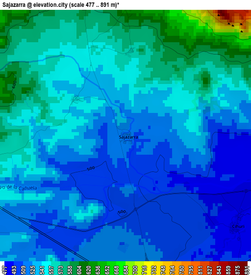
Below is the Elevation map of Sajazarra, which displays elevation range with different colors. Scale of the first map is from 477 to 891 m (1565 to 2923 ft) with average elevation of 540.7 meters (=1774 ft) [note 1]
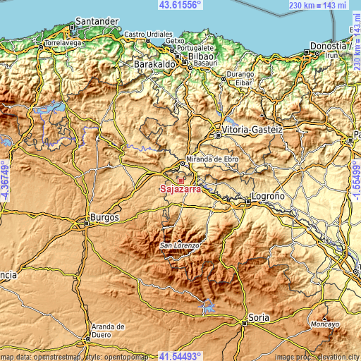
These maps also provides idea of topography and contour of this city, they are displayed at different zoom levels. More info about maps, scale and edge coordinates you can find below images.
| \ | Map #1 | Topo.Map |
| Scale [m] | 477..891 m | × |
| Scale [ft] | 1565..2923 ft | × |
| Average | 540.7 m = 1774 ft | × |
| Width | 7.19 km = 4.5 mi | 230.2 km = 143 mi |
| Height | 7.19 km = 4.5 mi | 230.2 km = 143 mi |
| ↑Max Latitude | 42.621185° | 43.61556° |
| Latitude at center | 42.58884° | 42.58884° |
| ↓Min Latitude | 42.556478° | 41.54493° |
| ← Min Longitude | -3.005185° | -4.36749° |
| Longitude center | -2.96124° | -2.96124° |
| →Max Longitude | -2.917295° | -1.55499° |
Nearby cities:
Cities around Sajazarra sort by population:
• Casalarreina elevation 502 m
6.1 km,  136°
136°
• Anguciana 474 m
5.2 km,  108°
108°
• Tirgo 524 m
4.9 km,  168°
168°
• Treviana 581 m
8 km,  245°
245°
• Villalba de Rioja 571 m
6.5 km,  69°
69°
• Cihuri 487 m
4.1 km,  130°
130°
• Fonzaleche 555 m
4.3 km,  258°
258°
• Foncea 694 m
7 km,  294°
294°
• Ochánduri 551 m
7.9 km,  206°
206°
• Galbárruli 651 m
3.7 km,  0°
0°
• Cellorigo 768 m
5.3 km,  323°
323°
• Cuzcurrita de Río Tirón 523 m
5.3 km,  182°
182°
Multilingual:
 En español:
Sajazarra elevación 521 m.
 En France:
Sajazarra élévation 521 m.
 Auf Deutsch:
Sajazarra höhe über dem Meeresspiegel ist 521 m.

Sources and notes:
- [note 1] Map square and city borders are not equal. Map elevation data is calculated only from area inside that square.
- [src 1] Elevation data from geonames database provided with same terms of usage.
- [src 2] The elevation map of Sajazarra is generated using elevation data from NASA's 3 arcsec (90m) resolution SRTM data.
- [src 3] Base (background) map © OpenStreetMap contributors tiles are generated by Geofabrik and OpenTopoMap.
Copyright & License:
This Sajazarra Elevation Map is licensed under CC BY-SA. You may reuse any part from this page, if you give a proper credit by linking to this URL:
 More info on terms of use page.