Tirgo elevation
Tirgo (La Rioja, Provincia de La Rioja), Spain elevation is 524 meters and Tirgo elevation in feet is 1719 ft above sea level [src 1]. Tirgo is a seat of a third-order administrative division (feature code) with elevation that is 79 meters (259 ft) smaller than average city elevation in Spain.
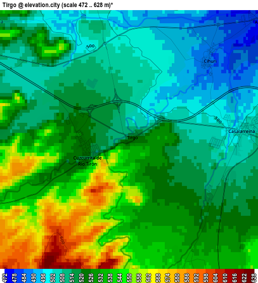
Below is the Elevation map of Tirgo, which displays elevation range with different colors. Scale of the first map is from 472 to 628 m (1549 to 2060 ft) with average elevation of 523.8 meters (=1719 ft) [note 1]
These maps also provides idea of topography and contour of this city, they are displayed at different zoom levels. More info about maps, scale and edge coordinates you can find below images.
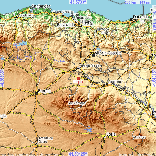
| \ | Map #1 | Topo.Map |
| Scale [m] | 472..628 m | × |
| Scale [ft] | 1549..2060 ft | × |
| Average | 523.8 m = 1719 ft | × |
| Width | 7.2 km = 4.5 mi | 230.4 km = 143.2 mi |
| Height | 7.2 km = 4.5 mi | 230.4 km = 143.2 mi |
| ↑Max Latitude | 42.578238° | 43.5733° |
| Latitude at center | 42.54587° | 42.54587° |
| ↓Min Latitude | 42.513486° | 41.50125° |
| ← Min Longitude | -2.993345° | -4.35565° |
| Longitude center | -2.9494° | -2.9494° |
| →Max Longitude | -2.905455° | -1.54315° |
Nearby cities:
Cities around Tirgo sort by population:
• Casalarreina elevation 502 m
3.3 km,  83°
83°
• Castañares de Rioja 543 m
4 km,  158°
158°
• Anguciana 474 m
5 km,  51°
51°
• Zarratón 557 m
6.5 km,  120°
120°
• Cihuri 487 m
3 km, 45°
• Fonzaleche 555 m
6.5 km,  307°
307°
• Herramélluri 570 m
7.5 km,  230°
230°
• Sajazarra 521 m
4.9 km,  348°
348°
• Baños de Rioja 557 m
3.7 km,  176°
176°
• Villalobar de Rioja 581 m
6.2 km,  191°
191°
• Ochánduri 551 m
5 km,  242°
242°
• Cuzcurrita de Río Tirón 523 m
1.3 km,  248°
248°
Multilingual:
 En español:
Tirgo elevación 524 m.
 En France:
Tirgo élévation 524 m.


Sources and notes:
- [note 1] Map square and city borders are not equal. Map elevation data is calculated only from area inside that square.
- [src 1] Elevation data from geonames database provided with same terms of usage.
- [src 2] The elevation map of Tirgo is generated using elevation data from NASA's 3 arcsec (90m) resolution SRTM data.
- [src 3] Base (background) map © OpenStreetMap contributors tiles are generated by Geofabrik and OpenTopoMap.
Copyright & License:
This Tirgo Elevation Map is licensed under CC BY-SA. You may reuse any part from this page, if you give a proper credit by linking to this URL:
 More info on terms of use page.