Alarcón elevation
Alarcón (Castille-La Mancha, Provincia de Cuenca), Spain elevation is 784 meters and Alarcón elevation in feet is 2572 ft above sea level [src 1]. Alarcón is a seat of a third-order administrative division (feature code) with elevation that is 181 meters (594 ft) bigger than average city elevation in Spain.
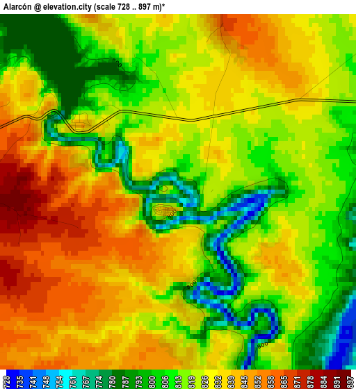
Below is the Elevation map of Alarcón, which displays elevation range with different colors. Scale of the first map is from 728 to 897 m (2388 to 2943 ft) with average elevation of 823.9 meters (=2703 ft) [note 1]
These maps also provides idea of topography and contour of this city, they are displayed at different zoom levels. More info about maps, scale and edge coordinates you can find below images.
| \ | Map #1 | Topo.Map |
| Scale [m] | 728..897 m | × |
| Scale [ft] | 2388..2943 ft | × |
| Average | 823.9 m = 2703 ft | × |
| Width | 7.54 km = 4.7 mi | 241.1 km = 149.8 mi |
| Height | 7.54 km = 4.7 mi | 241.1 km = 149.8 mi |
| ↑Max Latitude | 39.583877° | 40.62582° |
| Latitude at center | 39.55° | 39.55° |
| ↓Min Latitude | 39.516107° | 38.45723° |
| ← Min Longitude | -2.127275° | -3.48958° |
| Longitude center | -2.08333° | -2.08333° |
| →Max Longitude | -2.039385° | -0.67708° |
Nearby cities:
Cities around Alarcón sort by population:
• Motilla del Palancar elevation 846 m
17.2 km,  83°
83°
• Villanueva de la Jara 800 m
18.3 km,  135°
135°
• Honrubia 817 m
18.3 km,  292°
292°
• Buenache de Alarcón 829 m
13.2 km,  327°
327°
• Tébar 881 m
9.1 km,  232°
232°
• Gabaldón 921 m
14.8 km,  60°
60°
• Olmedilla de Alarcón 842 m
7.5 km,  349°
349°
• Valverdejo 897 m
9.4 km,  37°
37°
• Atalaya del Cañavate 820 m
14.9 km,  256°
256°
• Barchín del Hoyo 962 m
13.1 km,  6°
6°
• Piqueras del Castillo 949 m
18.6 km,  4°
4°
• Valhermoso de la Fuente 829 m
6 km,  72°
72°
Multilingual:
 En español:
Alarcón elevación 784 m.
 En France:
Alarcón élévation 784 m.


Sources and notes:
- [note 1] Map square and city borders are not equal. Map elevation data is calculated only from area inside that square.
- [src 1] Elevation data from geonames database provided with same terms of usage.
- [src 2] The elevation map of Alarcón is generated using elevation data from NASA's 3 arcsec (90m) resolution SRTM data.
- [src 3] Base (background) map © OpenStreetMap contributors tiles are generated by Geofabrik and OpenTopoMap.
Copyright & License:
This Alarcón Elevation Map is licensed under CC BY-SA. You may reuse any part from this page, if you give a proper credit by linking to this URL:
 More info on terms of use page.