Tébar elevation
Tébar (Castille-La Mancha, Provincia de Cuenca), Spain elevation is 881 meters and Tébar elevation in feet is 2890 ft above sea level [src 1]. Tébar is a seat of a third-order administrative division (feature code) with elevation that is 278 meters (912 ft) bigger than average city elevation in Spain.
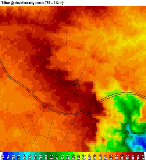
Below is the Elevation map of Tébar, which displays elevation range with different colors. Scale of the first map is from 756 to 913 m (2480 to 2995 ft) with average elevation of 874.7 meters (=2870 ft) [note 1]
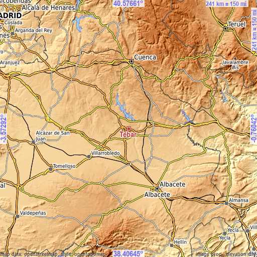
These maps also provides idea of topography and contour of this city, they are displayed at different zoom levels. More info about maps, scale and edge coordinates you can find below images.
| \ | Map #1 | Topo.Map |
| Scale [m] | 756..913 m | × |
| Scale [ft] | 2480..2995 ft | × |
| Average | 874.7 m = 2870 ft | × |
| Width | 7.54 km = 4.7 mi | 241.3 km = 149.9 mi |
| Height | 7.54 km = 4.7 mi | 241.3 km = 149.9 mi |
| ↑Max Latitude | 39.533901° | 40.57661° |
| Latitude at center | 39.5° | 39.5° |
| ↓Min Latitude | 39.466082° | 38.40645° |
| ← Min Longitude | -2.210615° | -3.57292° |
| Longitude center | -2.16667° | -2.16667° |
| →Max Longitude | -2.122725° | -0.76042° |
Nearby cities:
Cities around Tébar sort by population:
• Sisante elevation 743 m
10.6 km,  196°
196°
• Honrubia 817 m
16 km,  322°
322°
• Casas de Benítez 752 m
15.1 km,  169°
169°
• Buenache de Alarcón 829 m
16.7 km,  0°
0°
• Vara de Rey 820 m
13.7 km,  233°
233°
• Pozoamargo 751 m
15.2 km,  189°
189°
• Alarcón 784 m
9.1 km,  52°
52°
• Olmedilla de Alarcón 842 m
14.2 km,  23°
23°
• Casas de Guijarro 740 m
16.7 km,  180°
180°
• Valverdejo 897 m
18.3 km,  44°
44°
• Atalaya del Cañavate 820 m
7.6 km,  285°
285°
• Valhermoso de la Fuente 829 m
14.8 km,  60°
60°
Multilingual:
 En español:
Tébar elevación 881 m.
 En France:
Tébar élévation 881 m.


Sources and notes:
- [note 1] Map square and city borders are not equal. Map elevation data is calculated only from area inside that square.
- [src 1] Elevation data from geonames database provided with same terms of usage.
- [src 2] The elevation map of Tébar is generated using elevation data from NASA's 3 arcsec (90m) resolution SRTM data.
- [src 3] Base (background) map © OpenStreetMap contributors tiles are generated by Geofabrik and OpenTopoMap.
Copyright & License:
This Tébar Elevation Map is licensed under CC BY-SA. You may reuse any part from this page, if you give a proper credit by linking to this URL:
 More info on terms of use page.