Sisante elevation
Sisante (Castille-La Mancha, Provincia de Cuenca), Spain elevation is 743 meters and Sisante elevation in feet is 2438 ft above sea level [src 1]. Sisante is a seat of a third-order administrative division (feature code) with elevation that is 140 meters (459 ft) bigger than average city elevation in Spain.
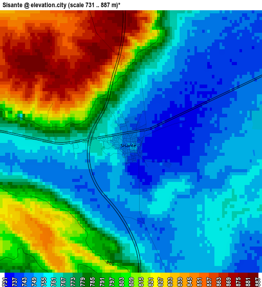
Below is the Elevation map of Sisante, which displays elevation range with different colors. Scale of the first map is from 731 to 887 m (2398 to 2910 ft) with average elevation of 779.8 meters (=2558 ft) [note 1]
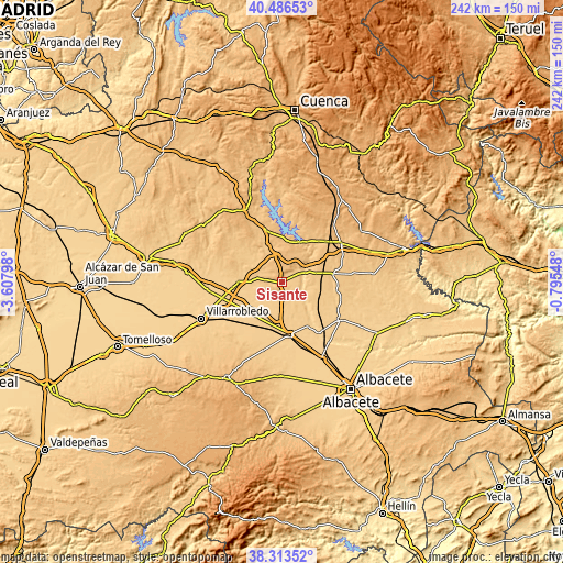
These maps also provides idea of topography and contour of this city, they are displayed at different zoom levels. More info about maps, scale and edge coordinates you can find below images.
| \ | Map #1 | Topo.Map |
| Scale [m] | 731..887 m | × |
| Scale [ft] | 2398..2910 ft | × |
| Average | 779.8 m = 2558 ft | × |
| Width | 7.55 km = 4.7 mi | 241.6 km = 150.1 mi |
| Height | 7.55 km = 4.7 mi | 241.6 km = 150.1 mi |
| ↑Max Latitude | 39.442436° | 40.48653° |
| Latitude at center | 39.40849° | 39.40849° |
| ↓Min Latitude | 39.374528° | 38.31352° |
| ← Min Longitude | -2.245675° | -3.60798° |
| Longitude center | -2.20173° | -2.20173° |
| →Max Longitude | -2.157785° | -0.79548° |
Nearby cities:
Cities around Sisante sort by population:
• Casasimarro elevation 768 m
15.2 km,  107°
107°
• Minaya 730 m
18.5 km,  213°
213°
• Casas de Fernando Alonso 725 m
12.3 km,  238°
238°
• Villagordo del Júcar 672 m
16.7 km,  136°
136°
• Casas de Benítez 752 m
7.5 km,  128°
128°
• Casas de Haro 724 m
10.3 km,  216°
216°
• Vara de Rey 820 m
8.2 km,  283°
283°
• Casas de los Pinos 727 m
16.7 km, 240°
• Tébar 881 m
10.6 km,  16°
16°
• Pozoamargo 751 m
4.8 km,  174°
174°
• Casas de Guijarro 740 m
7.2 km,  155°
155°
• Atalaya del Cañavate 820 m
13 km,  340°
340°
Multilingual:
 En español:
Sisante elevación 743 m.
 En France:
Sisante élévation 743 m.


Sources and notes:
- [note 1] Map square and city borders are not equal. Map elevation data is calculated only from area inside that square.
- [src 1] Elevation data from geonames database provided with same terms of usage.
- [src 2] The elevation map of Sisante is generated using elevation data from NASA's 3 arcsec (90m) resolution SRTM data.
- [src 3] Base (background) map © OpenStreetMap contributors tiles are generated by Geofabrik and OpenTopoMap.
Copyright & License:
This Sisante Elevation Map is licensed under CC BY-SA. You may reuse any part from this page, if you give a proper credit by linking to this URL:
 More info on terms of use page.