Gabaldón elevation
Gabaldón (Castille-La Mancha, Provincia de Cuenca), Spain elevation is 921 meters and Gabaldón elevation in feet is 3022 ft above sea level [src 1]. Gabaldón is a seat of a third-order administrative division (feature code) with elevation that is 318 meters (1043 ft) bigger than average city elevation in Spain.
Below is the Elevation map of Gabaldón, which displays elevation range with different colors. Scale of the first map is from 830 to 984 m (2723 to 3228 ft) with average elevation of 915.7 meters (=3004 ft) [note 1]
These maps also provides idea of topography and contour of this city, they are displayed at different zoom levels. More info about maps, scale and edge coordinates you can find below images.
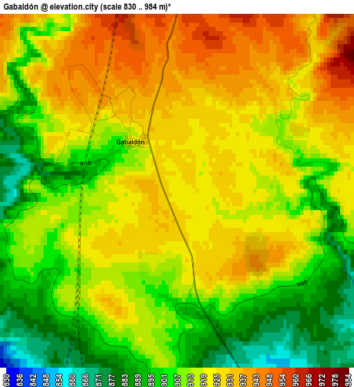
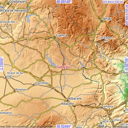
| \ | Map #1 | Topo.Map |
| Scale [m] | 830..984 m | × |
| Scale [ft] | 2723..3228 ft | × |
| Average | 915.7 m = 3004 ft | × |
| Width | 7.53 km = 4.7 mi | 240.9 km = 149.7 mi |
| Height | 7.53 km = 4.7 mi | 240.9 km = 149.7 mi |
| ↑Max Latitude | 39.650514° | 40.69145° |
| Latitude at center | 39.61667° | 39.61667° |
| ↓Min Latitude | 39.582809° | 38.52494° |
| ← Min Longitude | -1.977275° | -3.33958° |
| Longitude center | -1.93333° | -1.93333° |
| →Max Longitude | -1.889385° | -0.52708° |
Nearby cities:
Cities around Gabaldón sort by population:
• Motilla del Palancar elevation 846 m
7 km,  142°
142°
• Campillo de Altobuey 904 m
11.6 km,  99°
99°
• Almodóvar del Pinar 986 m
11.9 km,  21°
21°
• Castillejo de Iniesta 817 m
17 km,  122°
122°
• Alarcón 784 m
14.8 km,  240°
240°
• Paracuellos 922 m
17 km,  49°
49°
• Olmedilla de Alarcón 842 m
14.3 km,  270°
270°
• Valverdejo 897 m
7.1 km, 270°
• Barchín del Hoyo 962 m
12.7 km,  295°
295°
• Piqueras del Castillo 949 m
15.9 km,  314°
314°
• Chumillas 1033 m
18.7 km,  332°
332°
• Valhermoso de la Fuente 829 m
9 km,  232°
232°
Multilingual:
 En español:
Gabaldón elevación 921 m.
 En France:
Gabaldón élévation 921 m.
 Auf Deutsch:
Gabaldón höhe über dem Meeresspiegel ist 921 m.

Sources and notes:
- [note 1] Map square and city borders are not equal. Map elevation data is calculated only from area inside that square.
- [src 1] Elevation data from geonames database provided with same terms of usage.
- [src 2] The elevation map of Gabaldón is generated using elevation data from NASA's 3 arcsec (90m) resolution SRTM data.
- [src 3] Base (background) map © OpenStreetMap contributors tiles are generated by Geofabrik and OpenTopoMap.
Copyright & License:
This Gabaldón Elevation Map is licensed under CC BY-SA. You may reuse any part from this page, if you give a proper credit by linking to this URL:
 More info on terms of use page.