Albarreal de Tajo elevation
Albarreal de Tajo (Castille-La Mancha, Province of Toledo), Spain elevation is 451 meters and Albarreal de Tajo elevation in feet is 1480 ft above sea level [src 1]. Albarreal de Tajo is a seat of a third-order administrative division (feature code) with elevation that is 152 meters (499 ft) smaller than average city elevation in Spain.
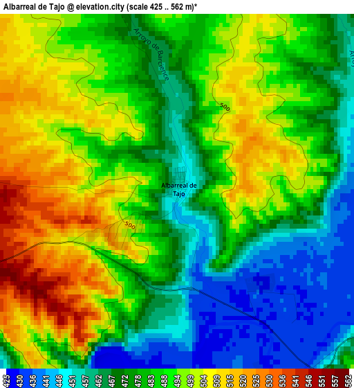
Below is the Elevation map of Albarreal de Tajo, which displays elevation range with different colors. Scale of the first map is from 425 to 562 m (1394 to 1844 ft) with average elevation of 483 meters (=1585 ft) [note 1]
These maps also provides idea of topography and contour of this city, they are displayed at different zoom levels. More info about maps, scale and edge coordinates you can find below images.
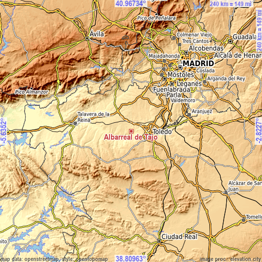
| \ | Map #1 | Topo.Map |
| Scale [m] | 425..562 m | × |
| Scale [ft] | 1394..1844 ft | × |
| Average | 483 m = 1585 ft | × |
| Width | 7.5 km = 4.7 mi | 239.9 km = 149.1 mi |
| Height | 7.5 km = 4.7 mi | 239.9 km = 149.1 mi |
| ↑Max Latitude | 39.930687° | 40.96734° |
| Latitude at center | 39.89698° | 39.89698° |
| ↓Min Latitude | 39.863257° | 38.80963° |
| ← Min Longitude | -4.272895° | -5.6352° |
| Longitude center | -4.22895° | -4.22895° |
| →Max Longitude | -4.185005° | -2.8227° |
Nearby cities:
Cities around Albarreal de Tajo sort by population:
• Torrijos elevation 531 m
10.5 km,  333°
333°
• La Puebla de Montalbán 490 m
11.7 km,  251°
251°
• Polán 650 m
13.2 km,  156°
156°
• Gerindote 551 m
9.9 km,  320°
320°
• Guadamur 629 m
11.7 km,  144°
144°
• Escalonilla 545 m
10.9 km,  287°
287°
• Burujón 500 m
5.8 km,  274°
274°
• Carmena 559 m
16.1 km, 293°
• Villamiel de Toledo 483 m
11.6 km,  49°
49°
• Rielves 498 m
7.9 km,  22°
22°
• Huecas 555 m
13.1 km,  12°
12°
• Barcience 517 m
9.7 km,  357°
357°
Multilingual:
 En español:
Albarreal de Tajo elevación 451 m.
 En France:
Albarreal de Tajo élévation 451 m.
 Auf Deutsch:
Albarreal de Tajo höhe über dem Meeresspiegel ist 451 m.

Sources and notes:
- [note 1] Map square and city borders are not equal. Map elevation data is calculated only from area inside that square.
- [src 1] Elevation data from geonames database provided with same terms of usage.
- [src 2] The elevation map of Albarreal de Tajo is generated using elevation data from NASA's 3 arcsec (90m) resolution SRTM data.
- [src 3] Base (background) map © OpenStreetMap contributors tiles are generated by Geofabrik and OpenTopoMap.
Copyright & License:
This Albarreal de Tajo Elevation Map is licensed under CC BY-SA. You may reuse any part from this page, if you give a proper credit by linking to this URL:
 More info on terms of use page.