Polán elevation
Polán (Castille-La Mancha, Province of Toledo), Spain elevation is 650 meters and Polán elevation in feet is 2133 ft above sea level [src 1]. Polán is a seat of a third-order administrative division (feature code) with elevation that is 47 meters (154 ft) bigger than average city elevation in Spain.
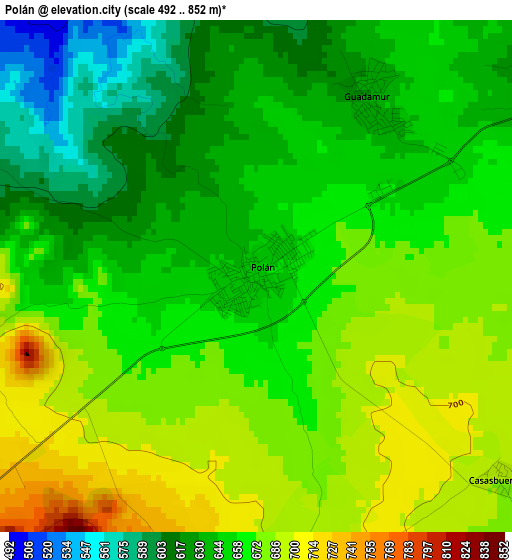
Below is the Elevation map of Polán, which displays elevation range with different colors. Scale of the first map is from 492 to 852 m (1614 to 2795 ft) with average elevation of 658.7 meters (=2161 ft) [note 1]
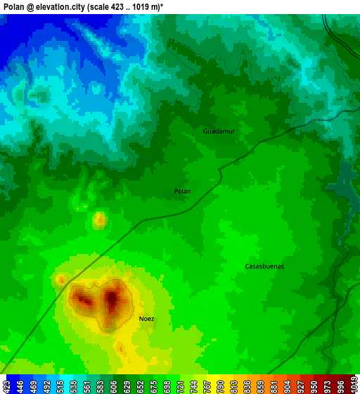
These maps also provides idea of topography and contour of this city, they are displayed at different zoom levels. More info about maps, scale and edge coordinates you can find below images.
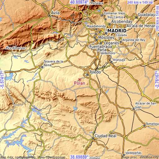
| \ | Map #1 | Map #2 | Topo.Map |
| Scale [m] | 492..852 m | 423..1019 m | × |
| Scale [ft] | 1614..2795 ft | 1388..3343 ft | × |
| Average | 658.7 m = 2161 ft | 638.1 m = 2094 ft | × |
| Width | 7.51 km = 4.7 mi | 15.02 km = 9.3 mi | 240.3 km = 149.3 mi |
| Height | 7.51 km = 4.7 mi | 15.02 km = 9.3 mi | 240.3 km = 149.3 mi |
| ↑Max Latitude | 39.82141° | 39.855154° | 40.85974° |
| Latitude at center | 39.78765° | 39.78765° | 39.78765° |
| ↓Min Latitude | 39.753873° | 39.72008° | 38.69859° |
| ← Min Longitude | -4.211865° | -4.255811° | -5.57417° |
| Longitude center | -4.16792° | -4.16792° | -4.16792° |
| →Max Longitude | -4.123975° | -4.080029° | -2.76167° |
Nearby cities:
Cities around Polán sort by population:
• Toledo elevation 533 m
14.7 km,  57°
57°
• Gálvez 713 m
13 km,  223°
223°
• Cobisa 676 m
12.3 km,  81°
81°
• Guadamur 629 m
3.1 km,  31°
31°
• Burguillos de Toledo 680 m
15 km,  86°
86°
• Pulgar 723 m
10.5 km,  172°
172°
• Cuerva 774 m
14.3 km,  194°
194°
• Noez 759 m
5.4 km, 194°
• Albarreal de Tajo 451 m
13.2 km,  336°
336°
• Totanés 726 m
9.9 km,  210°
210°
• Layos 652 m
8.9 km,  97°
97°
• Casasbuenas 686 m
4.7 km,  129°
129°
Multilingual:
 En español:
Polán elevación 650 m.
 En France:
Polán élévation 650 m.


Sources and notes:
- [note 1] Map square and city borders are not equal. Map elevation data is calculated only from area inside that square.
- [src 1] Elevation data from geonames database provided with same terms of usage.
- [src 2] The elevation map of Polán is generated using elevation data from NASA's 3 arcsec (90m) resolution SRTM data.
- [src 3] Base (background) map © OpenStreetMap contributors tiles are generated by Geofabrik and OpenTopoMap.
Copyright & License:
This Polán Elevation Map is licensed under CC BY-SA. You may reuse any part from this page, if you give a proper credit by linking to this URL:
 More info on terms of use page.