Cala elevation
Cala (Andalusia, Provincia de Huelva), Spain elevation is 608 meters and Cala elevation in feet is 1995 ft above sea level [src 1]. Cala is a seat of a third-order administrative division (feature code) with elevation that is 5 meters (16 ft) bigger than average city elevation in Spain.
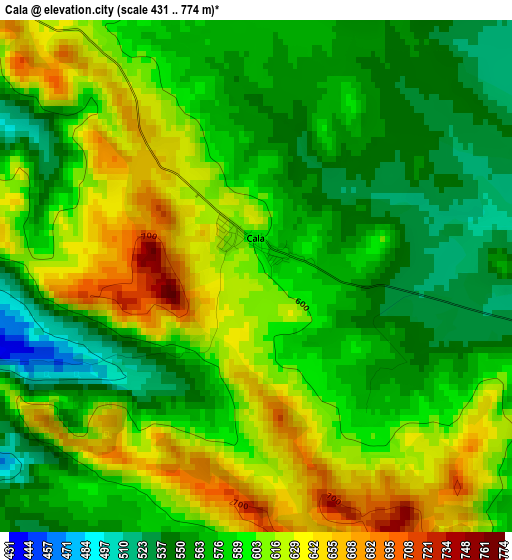
Below is the Elevation map of Cala, which displays elevation range with different colors. Scale of the first map is from 431 to 774 m (1414 to 2539 ft) with average elevation of 591 meters (=1939 ft) [note 1]
These maps also provides idea of topography and contour of this city, they are displayed at different zoom levels. More info about maps, scale and edge coordinates you can find below images.
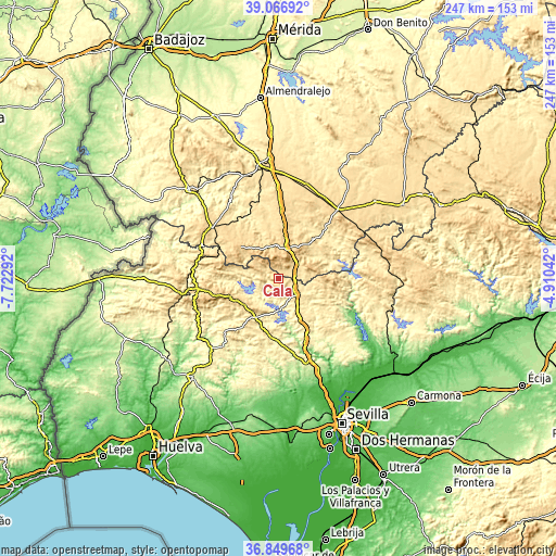
| \ | Map #1 | Topo.Map |
| Scale [m] | 431..774 m | × |
| Scale [ft] | 1414..2539 ft | × |
| Average | 591 m = 1939 ft | × |
| Width | 7.7 km = 4.8 mi | 246.5 km = 153.2 mi |
| Height | 7.7 km = 4.8 mi | 246.5 km = 153.2 mi |
| ↑Max Latitude | 38.001307° | 39.06692° |
| Latitude at center | 37.96667° | 37.96667° |
| ↓Min Latitude | 37.932017° | 36.84968° |
| ← Min Longitude | -6.360615° | -7.72292° |
| Longitude center | -6.31667° | -6.31667° |
| →Max Longitude | -6.272725° | -4.91042° |
Nearby cities:
Cities around Cala sort by population:
• Aracena elevation 675 m
22.9 km,  249°
249°
• Monesterio 731 m
13.7 km,  18°
18°
• Fuentes de León 757 m
22.5 km,  300°
300°
• Montemolín 660 m
22.8 km,  26°
26°
• Cabeza la Vaca 822 m
15.7 km,  325°
325°
• Calera de León 717 m
14.9 km,  354°
354°
• Higuera de la Sierra 612 m
18.9 km,  218°
218°
• Cañaveral de León 528 m
18.4 km,  287°
287°
• Corteconcepción 504 m
17.7 km, 245°
• Zufre 361 m
14.9 km,  185°
185°
• Santa Olalla del Cala 493 m
11.5 km,  130°
130°
• Arroyomolinos de León 564 m
10.4 km, 302°
Multilingual:
 En español:
Cala elevación 608 m.
 En France:
Cala élévation 608 m.


Sources and notes:
- [note 1] Map square and city borders are not equal. Map elevation data is calculated only from area inside that square.
- [src 1] Elevation data from geonames database provided with same terms of usage.
- [src 2] The elevation map of Cala is generated using elevation data from NASA's 3 arcsec (90m) resolution SRTM data.
- [src 3] Base (background) map © OpenStreetMap contributors tiles are generated by Geofabrik and OpenTopoMap.
Copyright & License:
This Cala Elevation Map is licensed under CC BY-SA. You may reuse any part from this page, if you give a proper credit by linking to this URL:
 More info on terms of use page.