Zufre elevation
Zufre (Andalusia, Provincia de Huelva), Spain elevation is 361 meters and Zufre elevation in feet is 1184 ft above sea level [src 1]. Zufre is a seat of a third-order administrative division (feature code) with elevation that is 242 meters (794 ft) smaller than average city elevation in Spain.
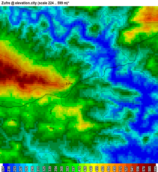
Below is the Elevation map of Zufre, which displays elevation range with different colors. Scale of the first map is from 224 to 599 m (735 to 1965 ft) with average elevation of 340.7 meters (=1118 ft) [note 1]
These maps also provides idea of topography and contour of this city, they are displayed at different zoom levels. More info about maps, scale and edge coordinates you can find below images.

| \ | Map #1 | Topo.Map |
| Scale [m] | 224..599 m | × |
| Scale [ft] | 735..1965 ft | × |
| Average | 340.7 m = 1118 ft | × |
| Width | 7.72 km = 4.8 mi | 247 km = 153.5 mi |
| Height | 7.72 km = 4.8 mi | 247 km = 153.5 mi |
| ↑Max Latitude | 37.86803° | 38.9356° |
| Latitude at center | 37.83333° | 37.83333° |
| ↓Min Latitude | 37.798614° | 36.71434° |
| ← Min Longitude | -6.377275° | -7.73958° |
| Longitude center | -6.33333° | -6.33333° |
| →Max Longitude | -6.289385° | -4.92708° |
Nearby cities:
Cities around Zufre sort by population:
• Aracena elevation 675 m
21.1 km,  288°
288°
• Nerva 336 m
24.4 km,  231°
231°
• El Castillo de las Guardas 333 m
15.7 km,  174°
174°
• El Ronquillo 334 m
18.2 km,  130°
130°
• Linares de la Sierra 502 m
26 km,  281°
281°
• Almadén de la Plata 454 m
22.6 km,  78°
78°
• Campofrío 523 m
22.4 km,  250°
250°
• Arroyomolinos de León 564 m
21.7 km,  340°
340°
• Corteconcepción 504 m
16.4 km,  296°
296°
• Cala 608 m
14.9 km,  5°
5°
• Santa Olalla del Cala 493 m
12.6 km,  54°
54°
• Higuera de la Sierra 612 m
10.2 km,  270°
270°
Multilingual:
 En español:
Zufre elevación 361 m.
 En France:
Zufre élévation 361 m.


Sources and notes:
- [note 1] Map square and city borders are not equal. Map elevation data is calculated only from area inside that square.
- [src 1] Elevation data from geonames database provided with same terms of usage.
- [src 2] The elevation map of Zufre is generated using elevation data from NASA's 3 arcsec (90m) resolution SRTM data.
- [src 3] Base (background) map © OpenStreetMap contributors tiles are generated by Geofabrik and OpenTopoMap.
Copyright & License:
This Zufre Elevation Map is licensed under CC BY-SA. You may reuse any part from this page, if you give a proper credit by linking to this URL:
 More info on terms of use page.