Montemolín elevation
Montemolín (Extremadura, Provincia de Badajoz), Spain elevation is 660 meters and Montemolín elevation in feet is 2165 ft above sea level [src 1]. Montemolín is a populated place (feature code) with elevation that is 57 meters (187 ft) bigger than average city elevation in Spain.
Below is the Elevation map of Montemolín, which displays elevation range with different colors. Scale of the first map is from 432 to 750 m (1417 to 2461 ft) with average elevation of 566.9 meters (=1860 ft) [note 1]
These maps also provides idea of topography and contour of this city, they are displayed at different zoom levels. More info about maps, scale and edge coordinates you can find below images.
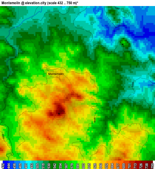
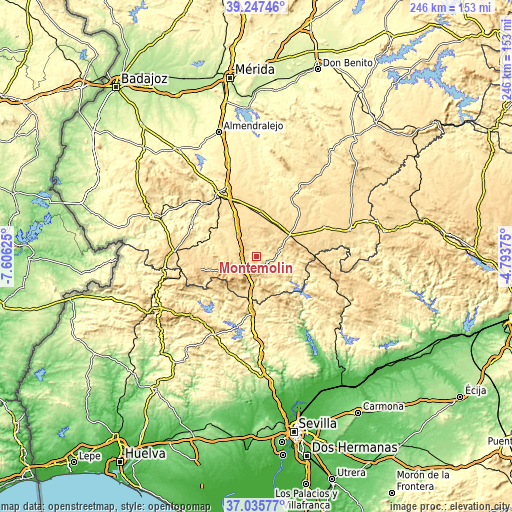
| \ | Map #1 | Topo.Map |
| Scale [m] | 432..750 m | × |
| Scale [ft] | 1417..2461 ft | × |
| Average | 566.9 m = 1860 ft | × |
| Width | 7.69 km = 4.8 mi | 245.9 km = 152.8 mi |
| Height | 7.69 km = 4.8 mi | 245.9 km = 152.8 mi |
| ↑Max Latitude | 38.18455° | 39.24746° |
| Latitude at center | 38.15° | 38.15° |
| ↓Min Latitude | 38.115433° | 37.03577° |
| ← Min Longitude | -6.243945° | -7.60625° |
| Longitude center | -6.2° | -6.2° |
| →Max Longitude | -6.156055° | -4.79375° |
Nearby cities:
Cities around Montemolín sort by population:
• Llerena elevation 650 m
18.5 km,  59°
59°
• Fuente de Cantos 607 m
14.1 km,  321°
321°
• Monesterio 731 m
9.4 km,  218°
218°
• Bienvenida 611 m
16.7 km,  0°
0°
• Usagre 567 m
22.4 km,  7°
7°
• Cabeza la Vaca 822 m
20.4 km,  248°
248°
• Calera de León 717 m
12.9 km,  244°
244°
• Villagarcía de la Torre 582 m
19.5 km,  31°
31°
• Puebla del Maestre 564 m
12.6 km,  125°
125°
• Casas de Reina 639 m
21.1 km,  74°
74°
• Reina 697 m
22.2 km,  80°
80°
• Trasierra 651 m
17.9 km, 78°
Multilingual:
 En español:
Montemolín elevación 660 m.
 En France:
Montemolín élévation 660 m.
 Auf Deutsch:
Montemolín höhe über dem Meeresspiegel ist 660 m.

Sources and notes:
- [note 1] Map square and city borders are not equal. Map elevation data is calculated only from area inside that square.
- [src 1] Elevation data from geonames database provided with same terms of usage.
- [src 2] The elevation map of Montemolín is generated using elevation data from NASA's 3 arcsec (90m) resolution SRTM data.
- [src 3] Base (background) map © OpenStreetMap contributors tiles are generated by Geofabrik and OpenTopoMap.
Copyright & License:
This Montemolín Elevation Map is licensed under CC BY-SA. You may reuse any part from this page, if you give a proper credit by linking to this URL:
 More info on terms of use page.