Fuente de Cantos elevation
Fuente de Cantos (Extremadura, Provincia de Badajoz), Spain elevation is 607 meters and Fuente de Cantos elevation in feet is 1991 ft above sea level [src 1]. Fuente de Cantos is a seat of a third-order administrative division (feature code) with elevation that is 4 meters (13 ft) bigger than average city elevation in Spain.
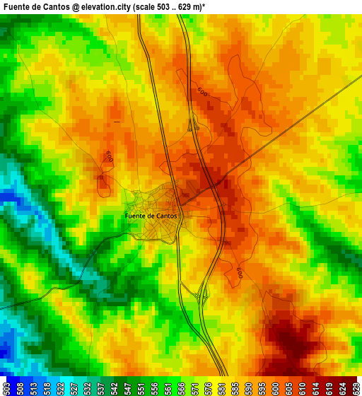
Below is the Elevation map of Fuente de Cantos, which displays elevation range with different colors. Scale of the first map is from 503 to 629 m (1650 to 2064 ft) with average elevation of 578.1 meters (=1897 ft) [note 1]
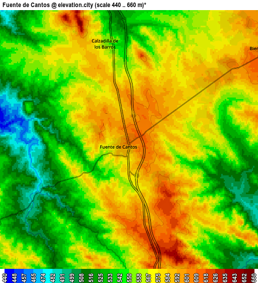
These maps also provides idea of topography and contour of this city, they are displayed at different zoom levels. More info about maps, scale and edge coordinates you can find below images.
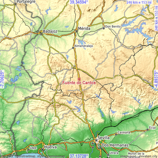
| \ | Map #1 | Map #2 | Topo.Map |
| Scale [m] | 503..629 m | 440..660 m | × |
| Scale [ft] | 1650..2064 ft | 1444..2165 ft | × |
| Average | 578.1 m = 1897 ft | 557.6 m = 1829 ft | × |
| Width | 7.67 km = 4.8 mi | 15.35 km = 9.5 mi | 245.6 km = 152.6 mi |
| Height | 7.67 km = 4.8 mi | 15.35 km = 9.5 mi | 245.6 km = 152.6 mi |
| ↑Max Latitude | 38.284503° | 38.318989° | 39.34594° |
| Latitude at center | 38.25° | 38.25° | 38.25° |
| ↓Min Latitude | 38.215481° | 38.180945° | 37.13728° |
| ← Min Longitude | -6.343945° | -6.387891° | -7.70625° |
| Longitude center | -6.3° | -6.3° | -6.3° |
| →Max Longitude | -6.256055° | -6.212109° | -4.89375° |
Nearby cities:
Cities around Fuente de Cantos sort by population:
• Zafra elevation 517 m
22 km,  332°
332°
• Monesterio 731 m
18.8 km,  171°
171°
• Puebla de Sancho Pérez 520 m
18.8 km, 332°
• Bienvenida 611 m
10.3 km,  57°
57°
• Valencia del Ventoso 522 m
14.7 km,  277°
277°
• Usagre 567 m
16.1 km,  46°
46°
• Montemolín 660 m
14.1 km,  141°
141°
• Cabeza la Vaca 822 m
21.2 km,  208°
208°
• Medina de las Torres 502 m
12.7 km,  316°
316°
• Calera de León 717 m
16.9 km,  189°
189°
• Villagarcía de la Torre 582 m
19.7 km,  73°
73°
• Atalaya 526 m
17.2 km,  302°
302°
Multilingual:
 En español:
Fuente de Cantos elevación 607 m.
 En France:
Fuente de Cantos élévation 607 m.
 Auf Deutsch:
Fuente de Cantos höhe über dem Meeresspiegel ist 607 m.

Sources and notes:
- [note 1] Map square and city borders are not equal. Map elevation data is calculated only from area inside that square.
- [src 1] Elevation data from geonames database provided with same terms of usage.
- [src 2] The elevation map of Fuente de Cantos is generated using elevation data from NASA's 3 arcsec (90m) resolution SRTM data.
- [src 3] Base (background) map © OpenStreetMap contributors tiles are generated by Geofabrik and OpenTopoMap.
Copyright & License:
This Fuente de Cantos Elevation Map is licensed under CC BY-SA. You may reuse any part from this page, if you give a proper credit by linking to this URL:
 More info on terms of use page.