Zafra elevation
Zafra (Extremadura, Provincia de Badajoz), Spain elevation is 517 meters and Zafra elevation in feet is 1696 ft above sea level [src 1]. Zafra is a seat of a third-order administrative division (feature code) with elevation that is 86 meters (282 ft) smaller than average city elevation in Spain.
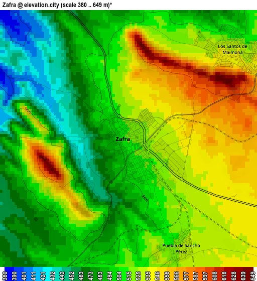
Below is the Elevation map of Zafra, which displays elevation range with different colors. Scale of the first map is from 380 to 649 m (1247 to 2129 ft) with average elevation of 508.4 meters (=1668 ft) [note 1]
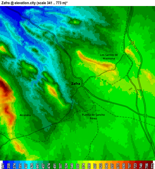
These maps also provides idea of topography and contour of this city, they are displayed at different zoom levels. More info about maps, scale and edge coordinates you can find below images.
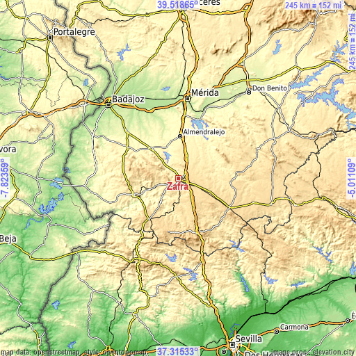
| \ | Map #1 | Map #2 | Topo.Map |
| Scale [m] | 380..649 m | 341..773 m | × |
| Scale [ft] | 1247..2129 ft | 1119..2536 ft | × |
| Average | 508.4 m = 1668 ft | 505.4 m = 1658 ft | × |
| Width | 7.66 km = 4.8 mi | 15.31 km = 9.5 mi | 245 km = 152.2 mi |
| Height | 7.66 km = 4.8 mi | 15.31 km = 9.5 mi | 245 km = 152.2 mi |
| ↑Max Latitude | 38.459809° | 38.494212° | 39.51865° |
| Latitude at center | 38.42539° | 38.42539° | 38.42539° |
| ↓Min Latitude | 38.390954° | 38.356502° | 37.31533° |
| ← Min Longitude | -6.461285° | -6.505231° | -7.82359° |
| Longitude center | -6.41734° | -6.41734° | -6.41734° |
| →Max Longitude | -6.373395° | -6.329449° | -5.01109° |
Nearby cities:
Cities around Zafra sort by population:
• Villafranca de los Barros elevation 422 m
16.6 km,  24°
24°
• Los Santos de Maimona 531 m
4 km,  47°
47°
• Fuente del Maestre 444 m
11.6 km,  346°
346°
• Burguillos del Cerro 405 m
15.9 km,  251°
251°
• Puebla de Sancho Pérez 520 m
3.2 km,  151°
151°
• Valencia del Ventoso 522 m
18.2 km,  193°
193°
• La Parra 519 m
20.8 km,  300°
300°
• Medina de las Torres 502 m
10.3 km,  171°
171°
• Feria 551 m
16 km,  306°
306°
• Alconera 467 m
5.1 km,  236°
236°
• Atalaya 526 m
11.1 km,  202°
202°
• Valverde de Burguillos 415 m
15.1 km,  223°
223°
Multilingual:
 En español:
Zafra elevación 517 m.
 En France:
Zafra élévation 517 m.


Sources and notes:
- [note 1] Map square and city borders are not equal. Map elevation data is calculated only from area inside that square.
- [src 1] Elevation data from geonames database provided with same terms of usage.
- [src 2] The elevation map of Zafra is generated using elevation data from NASA's 3 arcsec (90m) resolution SRTM data.
- [src 3] Base (background) map © OpenStreetMap contributors tiles are generated by Geofabrik and OpenTopoMap.
Copyright & License:
This Zafra Elevation Map is licensed under CC BY-SA. You may reuse any part from this page, if you give a proper credit by linking to this URL:
 More info on terms of use page.