La Parra elevation
La Parra (Extremadura, Provincia de Badajoz), Spain elevation is 519 meters and La Parra elevation in feet is 1703 ft above sea level [src 1]. La Parra is a populated place (feature code) with elevation that is 84 meters (276 ft) smaller than average city elevation in Spain.
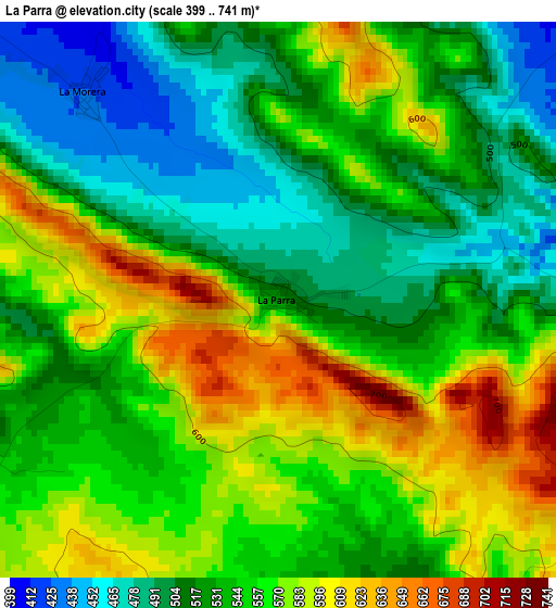
Below is the Elevation map of La Parra, which displays elevation range with different colors. Scale of the first map is from 399 to 741 m (1309 to 2431 ft) with average elevation of 544.6 meters (=1787 ft) [note 1]
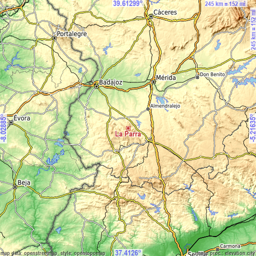
These maps also provides idea of topography and contour of this city, they are displayed at different zoom levels. More info about maps, scale and edge coordinates you can find below images.
| \ | Map #1 | Topo.Map |
| Scale [m] | 399..741 m | × |
| Scale [ft] | 1309..2431 ft | × |
| Average | 544.6 m = 1787 ft | × |
| Width | 7.65 km = 4.8 mi | 244.7 km = 152 mi |
| Height | 7.65 km = 4.8 mi | 244.7 km = 152 mi |
| ↑Max Latitude | 38.555574° | 39.61299° |
| Latitude at center | 38.5212° | 38.5212° |
| ↓Min Latitude | 38.48681° | 37.4126° |
| ← Min Longitude | -6.666545° | -8.02885° |
| Longitude center | -6.6226° | -6.6226° |
| →Max Longitude | -6.578655° | -5.21635° |
Nearby cities:
Cities around La Parra sort by population:
• Fuente del Maestre elevation 444 m
15.2 km,  87°
87°
• Aceuchal 307 m
18.3 km,  40°
40°
• Santa Marta 341 m
10.4 km,  357°
357°
• Barcarrota 489 m
19.7 km,  267°
267°
• Burguillos del Cerro 405 m
15.9 km,  169°
169°
• Salvaleón 531 m
14.3 km, 265°
• Salvatierra de los Barros 621 m
6.3 km,  237°
237°
• Villalba de los Barros 310 m
14.2 km, 44°
• Feria 551 m
5.2 km,  101°
101°
• Torre de Miguel Sesmero 322 m
18.6 km,  305°
305°
• Alconera 467 m
19.1 km,  134°
134°
• Nogales 373 m
13.2 km,  303°
303°
Multilingual:
 En español:
La Parra elevación 519 m.
 En France:
La Parra élévation 519 m.
 Auf Deutsch:
La Parra höhe über dem Meeresspiegel ist 519 m.

Sources and notes:
- [note 1] Map square and city borders are not equal. Map elevation data is calculated only from area inside that square.
- [src 1] Elevation data from geonames database provided with same terms of usage.
- [src 2] The elevation map of La Parra is generated using elevation data from NASA's 3 arcsec (90m) resolution SRTM data.
- [src 3] Base (background) map © OpenStreetMap contributors tiles are generated by Geofabrik and OpenTopoMap.
Copyright & License:
This La Parra Elevation Map is licensed under CC BY-SA. You may reuse any part from this page, if you give a proper credit by linking to this URL:
 More info on terms of use page.