Cardeña elevation
Cardeña (Andalusia, Province of Córdoba), Spain elevation is 747 meters and Cardeña elevation in feet is 2451 ft above sea level [src 1]. Cardeña is a seat of a third-order administrative division (feature code) with elevation that is 144 meters (472 ft) bigger than average city elevation in Spain.
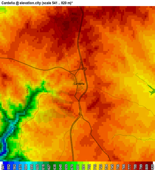
Below is the Elevation map of Cardeña, which displays elevation range with different colors. Scale of the first map is from 541 to 820 m (1775 to 2690 ft) with average elevation of 746.3 meters (=2448 ft) [note 1]
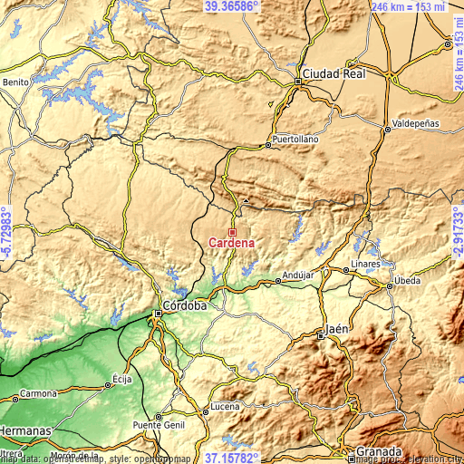
These maps also provides idea of topography and contour of this city, they are displayed at different zoom levels. More info about maps, scale and edge coordinates you can find below images.
| \ | Map #1 | Topo.Map |
| Scale [m] | 541..820 m | × |
| Scale [ft] | 1775..2690 ft | × |
| Average | 746.3 m = 2448 ft | × |
| Width | 7.67 km = 4.8 mi | 245.5 km = 152.5 mi |
| Height | 7.67 km = 4.8 mi | 245.5 km = 152.5 mi |
| ↑Max Latitude | 38.304723° | 39.36586° |
| Latitude at center | 38.27023° | 38.27023° |
| ↓Min Latitude | 38.23572° | 37.15782° |
| ← Min Longitude | -4.367525° | -5.72983° |
| Longitude center | -4.32358° | -4.32358° |
| →Max Longitude | -4.279635° | -2.91733° |
Nearby cities:
Cities around Cardeña sort by population:
• Andújar elevation 216 m
35.1 km,  137°
137°
• Villanueva de Córdoba 729 m
27.3 km,  282°
282°
• Montoro 195 m
27.9 km,  190°
190°
• Marmolejo 248 m
28.4 km,  151°
151°
• Villa del Río 168 m
32.3 km,  174°
174°
• Adamuz 237 m
32.2 km,  212°
212°
• Lopera 266 m
37.4 km, 165°
• Arjonilla 346 m
38 km, 150°
• Pedro Abad 159 m
35.7 km,  198°
198°
• Torrecampo 601 m
37 km,  306°
306°
• Conquista 594 m
21.1 km, 313°
• Fuencaliente 692 m
15.2 km,  6°
6°
Multilingual:
 En español:
Cárdenas elevación 747 m.
 En France:
Cardeña élévation 747 m.


Sources and notes:
- [note 1] Map square and city borders are not equal. Map elevation data is calculated only from area inside that square.
- [src 1] Elevation data from geonames database provided with same terms of usage.
- [src 2] The elevation map of Cardeña is generated using elevation data from NASA's 3 arcsec (90m) resolution SRTM data.
- [src 3] Base (background) map © OpenStreetMap contributors tiles are generated by Geofabrik and OpenTopoMap.
Copyright & License:
This Cardeña Elevation Map is licensed under CC BY-SA. You may reuse any part from this page, if you give a proper credit by linking to this URL:
 More info on terms of use page.