Andújar elevation
Andújar (Andalusia, Provincia de Jaén), Spain elevation is 216 meters and Andújar elevation in feet is 709 ft above sea level [src 1]. Andújar is a seat of a third-order administrative division (feature code) with elevation that is 387 meters (1270 ft) smaller than average city elevation in Spain.
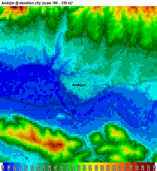
Below is the Elevation map of Andújar, which displays elevation range with different colors. Scale of the first map is from 190 to 339 m (623 to 1112 ft) with average elevation of 227.1 meters (=745 ft) [note 1]
These maps also provides idea of topography and contour of this city, they are displayed at different zoom levels. More info about maps, scale and edge coordinates you can find below images.
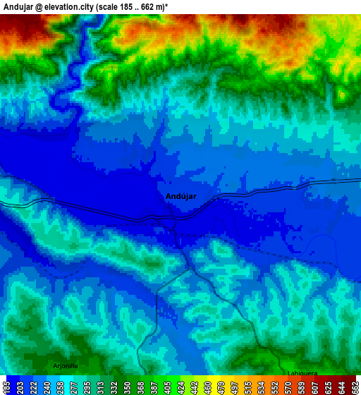
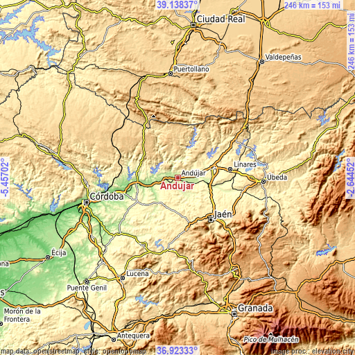
| \ | Map #1 | Map #2 | Topo.Map |
| Scale [m] | 190..339 m | 185..662 m | × |
| Scale [ft] | 623..1112 ft | 607..2172 ft | × |
| Average | 227.1 m = 745 ft | 284.2 m = 932 ft | × |
| Width | 7.7 km = 4.8 mi | 15.39 km = 9.6 mi | 246.3 km = 153 mi |
| Height | 7.7 km = 4.8 mi | 15.39 km = 9.6 mi | 246.3 km = 153 mi |
| ↑Max Latitude | 38.073823° | 38.108409° | 39.13837° |
| Latitude at center | 38.03922° | 38.03922° | 38.03922° |
| ↓Min Latitude | 38.004601° | 37.969966° | 36.92333° |
| ← Min Longitude | -4.094715° | -4.138661° | -5.45702° |
| Longitude center | -4.05077° | -4.05077° | -4.05077° |
| →Max Longitude | -4.006825° | -3.962879° | -2.64452° |
Nearby cities:
Cities around Andújar sort by population:
• Mengibar elevation 304 m
22.6 km,  110°
110°
• Marmolejo 248 m
10.5 km,  273°
273°
• Villa del Río 168 m
21.9 km,  252°
252°
• Porcuna 472 m
22.1 km,  212°
212°
• Arjona 452 m
11.6 km,  181°
181°
• Lopera 266 m
17.7 km,  234°
234°
• Arjonilla 346 m
8.7 km, 214°
• Villanueva de la Reina 223 m
12.4 km, 108°
• Higuera de Arjona 376 m
9.3 km,  145°
145°
• Escañuela 317 m
17.9 km, 175°
• Cazalilla 298 m
15.9 km, 112°
• Espelúy 280 m
16.5 km,  92°
92°
Multilingual:
 En español:
Andújar elevación 216 m.
 En France:
Andújar élévation 216 m.


Sources and notes:
- [note 1] Map square and city borders are not equal. Map elevation data is calculated only from area inside that square.
- [src 1] Elevation data from geonames database provided with same terms of usage.
- [src 2] The elevation map of Andújar is generated using elevation data from NASA's 3 arcsec (90m) resolution SRTM data.
- [src 3] Base (background) map © OpenStreetMap contributors tiles are generated by Geofabrik and OpenTopoMap.
Copyright & License:
This Andújar Elevation Map is licensed under CC BY-SA. You may reuse any part from this page, if you give a proper credit by linking to this URL:
 More info on terms of use page.