Espelúy elevation
Espelúy (Andalusia, Provincia de Jaén), Spain elevation is 280 meters and Espelúy elevation in feet is 919 ft above sea level [src 1]. Espelúy is a seat of a third-order administrative division (feature code) with elevation that is 323 meters (1060 ft) smaller than average city elevation in Spain.
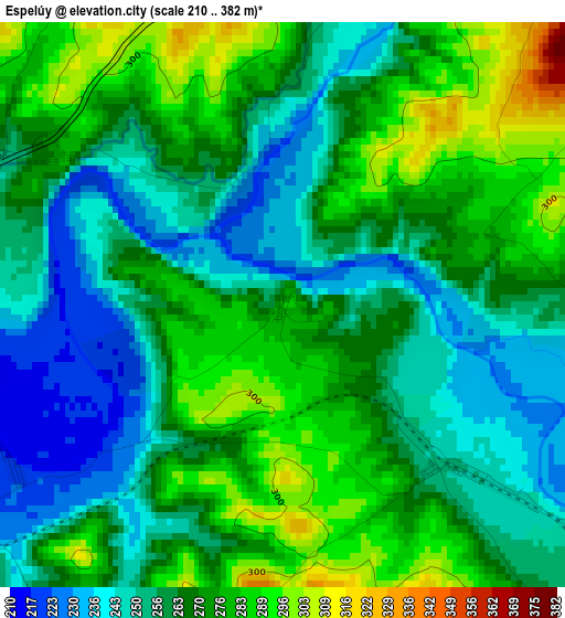
Below is the Elevation map of Espelúy, which displays elevation range with different colors. Scale of the first map is from 210 to 382 m (689 to 1253 ft) with average elevation of 265 meters (=869 ft) [note 1]
These maps also provides idea of topography and contour of this city, they are displayed at different zoom levels. More info about maps, scale and edge coordinates you can find below images.
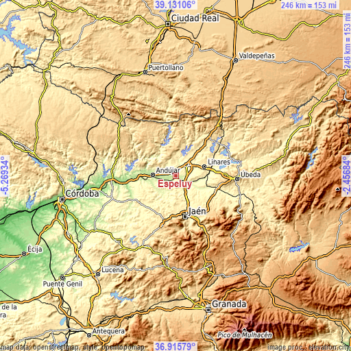
| \ | Map #1 | Topo.Map |
| Scale [m] | 210..382 m | × |
| Scale [ft] | 689..1253 ft | × |
| Average | 265 m = 869 ft | × |
| Width | 7.7 km = 4.8 mi | 246.3 km = 153 mi |
| Height | 7.7 km = 4.8 mi | 246.3 km = 153 mi |
| ↑Max Latitude | 38.066406° | 39.13106° |
| Latitude at center | 38.0318° | 38.0318° |
| ↓Min Latitude | 37.997177° | 36.91579° |
| ← Min Longitude | -3.907035° | -5.26934° |
| Longitude center | -3.86309° | -3.86309° |
| →Max Longitude | -3.819145° | -2.45684° |
Nearby cities:
Cities around Espelúy sort by population:
• Linares elevation 413 m
21.1 km,  70°
70°
• Andújar 216 m
16.5 km,  272°
272°
• Bailén 349 m
10.4 km,  46°
46°
• Mengibar 304 m
8.4 km,  145°
145°
• Arjona 452 m
20 km,  237°
237°
• Villanueva de la Reina 223 m
5.6 km, 236°
• Baños de la Encina 452 m
17.6 km,  26°
26°
• Torreblascopedro 333 m
20.1 km,  100°
100°
• Jabalquinto 490 m
12.2 km, 96°
• Higuera de Arjona 376 m
13.1 km, 238°
• Fuerte del Rey 428 m
17.5 km,  185°
185°
• Cazalilla 298 m
5.6 km,  198°
198°
Multilingual:
 En español:
Espelúy elevación 280 m.
 En France:
Espelúy élévation 280 m.


Sources and notes:
- [note 1] Map square and city borders are not equal. Map elevation data is calculated only from area inside that square.
- [src 1] Elevation data from geonames database provided with same terms of usage.
- [src 2] The elevation map of Espelúy is generated using elevation data from NASA's 3 arcsec (90m) resolution SRTM data.
- [src 3] Base (background) map © OpenStreetMap contributors tiles are generated by Geofabrik and OpenTopoMap.
Copyright & License:
This Espelúy Elevation Map is licensed under CC BY-SA. You may reuse any part from this page, if you give a proper credit by linking to this URL:
 More info on terms of use page.