Torreblascopedro elevation
Torreblascopedro (Andalusia, Provincia de Jaén), Spain elevation is 333 meters and Torreblascopedro elevation in feet is 1093 ft above sea level [src 1]. Torreblascopedro is a seat of a third-order administrative division (feature code) with elevation that is 270 meters (886 ft) smaller than average city elevation in Spain.
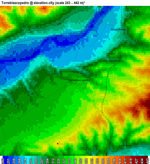
Below is the Elevation map of Torreblascopedro, which displays elevation range with different colors. Scale of the first map is from 243 to 442 m (797 to 1450 ft) with average elevation of 318.8 meters (=1046 ft) [note 1]
These maps also provides idea of topography and contour of this city, they are displayed at different zoom levels. More info about maps, scale and edge coordinates you can find below images.
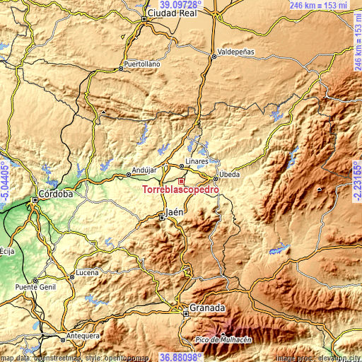
| \ | Map #1 | Topo.Map |
| Scale [m] | 243..442 m | × |
| Scale [ft] | 797..1450 ft | × |
| Average | 318.8 m = 1046 ft | × |
| Width | 7.7 km = 4.8 mi | 246.4 km = 153.1 mi |
| Height | 7.7 km = 4.8 mi | 246.4 km = 153.1 mi |
| ↑Max Latitude | 38.032122° | 39.09728° |
| Latitude at center | 37.9975° | 37.9975° |
| ↓Min Latitude | 37.962861° | 36.88098° |
| ← Min Longitude | -3.681745° | -5.04405° |
| Longitude center | -3.6378° | -3.6378° |
| →Max Longitude | -3.593855° | -2.23155° |
Nearby cities:
Cities around Torreblascopedro sort by population:
• Linares elevation 413 m
10.9 km,  0°
0°
• Bailén 349 m
16.5 km,  311°
311°
• Baeza 763 m
14.6 km,  91°
91°
• Mengibar 304 m
15.3 km,  258°
258°
• Rus 585 m
16.3 km,  70°
70°
• Begíjar 575 m
9.5 km,  98°
98°
• Ibros 597 m
12.1 km,  77°
77°
• Guarromán 350 m
21.1 km,  348°
348°
• Jabalquinto 490 m
8 km,  287°
287°
• Canena 518 m
14.7 km, 66°
• Lupión 503 m
8 km, 90°
• Espelúy 280 m
20.1 km,  280°
280°
Multilingual:
 En español:
Torreblascopedro elevación 333 m.
 En France:
Torreblascopedro élévation 333 m.
 Auf Deutsch:
Torreblascopedro höhe über dem Meeresspiegel ist 333 m.

Sources and notes:
- [note 1] Map square and city borders are not equal. Map elevation data is calculated only from area inside that square.
- [src 1] Elevation data from geonames database provided with same terms of usage.
- [src 2] The elevation map of Torreblascopedro is generated using elevation data from NASA's 3 arcsec (90m) resolution SRTM data.
- [src 3] Base (background) map © OpenStreetMap contributors tiles are generated by Geofabrik and OpenTopoMap.
Copyright & License:
This Torreblascopedro Elevation Map is licensed under CC BY-SA. You may reuse any part from this page, if you give a proper credit by linking to this URL:
 More info on terms of use page.