Chirivel elevation
Chirivel (Andalusia, Almería), Spain elevation is 1046 meters and Chirivel elevation in feet is 3432 ft above sea level [src 1]. Chirivel is a seat of a third-order administrative division (feature code) with elevation that is 443 meters (1453 ft) bigger than average city elevation in Spain.
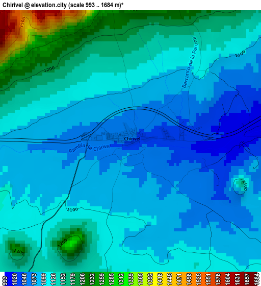
Below is the Elevation map of Chirivel, which displays elevation range with different colors. Scale of the first map is from 993 to 1684 m (3258 to 5525 ft) with average elevation of 1118.9 meters (=3671 ft) [note 1]
These maps also provides idea of topography and contour of this city, they are displayed at different zoom levels. More info about maps, scale and edge coordinates you can find below images.
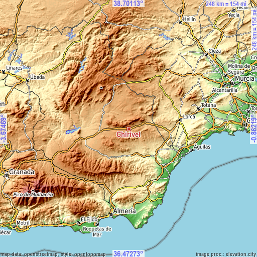
| \ | Map #1 | Topo.Map |
| Scale [m] | 993..1684 m | × |
| Scale [ft] | 3258..5525 ft | × |
| Average | 1118.9 m = 3671 ft | × |
| Width | 7.74 km = 4.8 mi | 247.8 km = 154 mi |
| Height | 7.74 km = 4.8 mi | 247.8 km = 154 mi |
| ↑Max Latitude | 37.630081° | 38.70113° |
| Latitude at center | 37.59527° | 37.59527° |
| ↓Min Latitude | 37.560442° | 36.47273° |
| ← Min Longitude | -2.312385° | -3.67469° |
| Longitude center | -2.26844° | -2.26844° |
| →Max Longitude | -2.224495° | -0.86219° |
Nearby cities:
Cities around Chirivel sort by population:
• Albox elevation 428 m
25.3 km,  155°
155°
• Velez Rubio 828 m
17.9 km,  70°
70°
• Oria 1028 m
12.4 km,  190°
190°
• Vélez-Blanco 1073 m
18.6 km,  54°
54°
• Fines 476 m
26.1 km,  177°
177°
• María 1200 m
15.7 km,  35°
35°
• Orce 941 m
23.1 km,  307°
307°
• Lúcar 889 m
25.7 km,  212°
212°
• Partaloa 540 m
21.2 km,  169°
169°
• Somontín 821 m
25 km, 205°
• Urrácal 749 m
23.6 km,  201°
201°
• Taberno 713 m
21.9 km,  129°
129°
Multilingual:
 En español:
Chirivel elevación 1046 m.
 En France:
Chirivel élévation 1046 m.
 Auf Deutsch:
Chirivel höhe über dem Meeresspiegel ist 1046 m.

Sources and notes:
- [note 1] Map square and city borders are not equal. Map elevation data is calculated only from area inside that square.
- [src 1] Elevation data from geonames database provided with same terms of usage.
- [src 2] The elevation map of Chirivel is generated using elevation data from NASA's 3 arcsec (90m) resolution SRTM data.
- [src 3] Base (background) map © OpenStreetMap contributors tiles are generated by Geofabrik and OpenTopoMap.
Copyright & License:
This Chirivel Elevation Map is licensed under CC BY-SA. You may reuse any part from this page, if you give a proper credit by linking to this URL:
 More info on terms of use page.