Gobernador elevation
Gobernador (Andalusia, Provincia de Granada), Spain elevation is 1038 meters and Gobernador elevation in feet is 3406 ft above sea level [src 1]. Gobernador is a seat of a third-order administrative division (feature code) with elevation that is 435 meters (1427 ft) bigger than average city elevation in Spain.
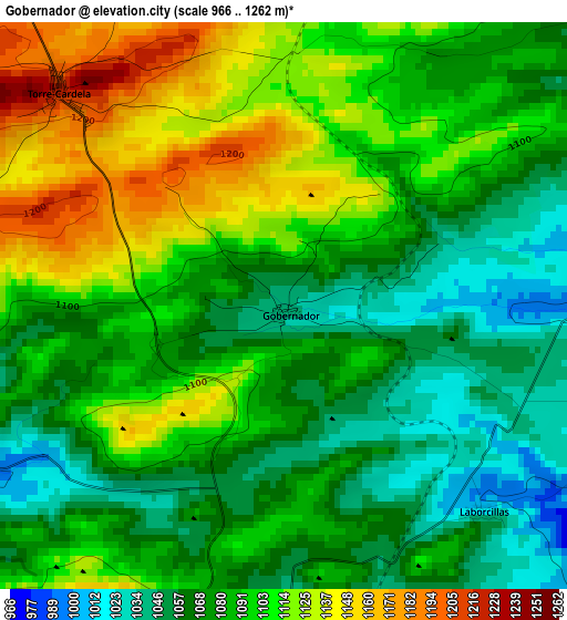
Below is the Elevation map of Gobernador, which displays elevation range with different colors. Scale of the first map is from 966 to 1262 m (3169 to 4140 ft) with average elevation of 1088.9 meters (=3573 ft) [note 1]
These maps also provides idea of topography and contour of this city, they are displayed at different zoom levels. More info about maps, scale and edge coordinates you can find below images.
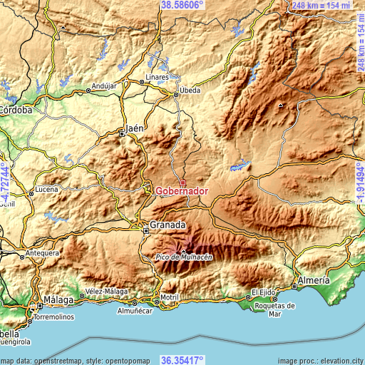
| \ | Map #1 | Topo.Map |
| Scale [m] | 966..1262 m | × |
| Scale [ft] | 3169..4140 ft | × |
| Average | 1088.9 m = 3573 ft | × |
| Width | 7.76 km = 4.8 mi | 248.2 km = 154.2 mi |
| Height | 7.76 km = 4.8 mi | 248.2 km = 154.2 mi |
| ↑Max Latitude | 37.513316° | 38.58606° |
| Latitude at center | 37.47845° | 37.47845° |
| ↓Min Latitude | 37.443568° | 36.35417° |
| ← Min Longitude | -3.365135° | -4.72744° |
| Longitude center | -3.32119° | -3.32119° |
| →Max Longitude | -3.277245° | -1.91494° |
Nearby cities:
Cities around Gobernador sort by population:
• Benalúa de Guadix elevation 874 m
19.8 km,  135°
135°
• Montejicar 1146 m
19.3 km,  302°
302°
• Guadahortuna 964 m
11.1 km,  322°
322°
• Darro 1133 m
14.5 km,  170°
170°
• Pedro Martínez 1040 m
8.4 km,  71°
71°
• Fonelas 773 m
15.2 km,  119°
119°
• Piñar 902 m
11 km,  250°
250°
• Torre-Cardela 1218 m
4.2 km,  313°
313°
• Alamedilla 862 m
13.5 km,  31°
31°
• Diezma 1223 m
17.7 km,  183°
183°
• Huélago 920 m
8.3 km, 141°
• Domingo Pérez 970 m
16.7 km,  276°
276°
Multilingual:
 En español:
Gobernador elevación 1038 m.
 En France:
Gobernador élévation 1038 m.
 Auf Deutsch:
Gobernador höhe über dem Meeresspiegel ist 1038 m.

Sources and notes:
- [note 1] Map square and city borders are not equal. Map elevation data is calculated only from area inside that square.
- [src 1] Elevation data from geonames database provided with same terms of usage.
- [src 2] The elevation map of Gobernador is generated using elevation data from NASA's 3 arcsec (90m) resolution SRTM data.
- [src 3] Base (background) map © OpenStreetMap contributors tiles are generated by Geofabrik and OpenTopoMap.
Copyright & License:
This Gobernador Elevation Map is licensed under CC BY-SA. You may reuse any part from this page, if you give a proper credit by linking to this URL:
 More info on terms of use page.